

11th October, 2022
The drizzle stopped last night and we could get glimpse of some stars. We noted that while returning to our room from the dining space. The day started with a “somewhat” clear sky. Clouds didn’t give up their claims on the upper reaches of the mountains totally. As I looked around, I was greeted with a mix of clear skies and cloud covers but wait, what was that! Wasn’t it our first glimpse of snow on this trip? Amidst the “V” opening between distant hills down the valley, there appeared a mountain peak. It wasn’t fully visible with it’s top still covered by clouds. Nature’s finally showing some mercy! Others also cast their gaze at this view and pretty soon there was a buzz around the place with sounds of mobile clicks and camera shutters. Our guide stated “Manaslu”.

It was difficult to recognize it since it appeared very different from what we saw from places like Lho or Samagaun (the famous double edged view) during the Manaslu Circuit trek. We all got excited, but Dhananjoy, more so. He’s normally interested in their names and makes sure he remembers them. Every video that he records, contains utterances by him citing the names of the mountains as his camera hovers around. Our breakfast was simple with noodle soup and we hit the trail at 7.45 AM. The day’s destination was Upper Pisang. Once we reach there, we’d move beyond the tropical zone and enter the rain shadow area of the Annapurna range. Places beyond that are expected to be drier, but much colder and windy. Going by forecast, weather was supposed to clear up from 12th. After exiting the tea house area, we crossed a pool and were greeted with apple trees in local orchards.
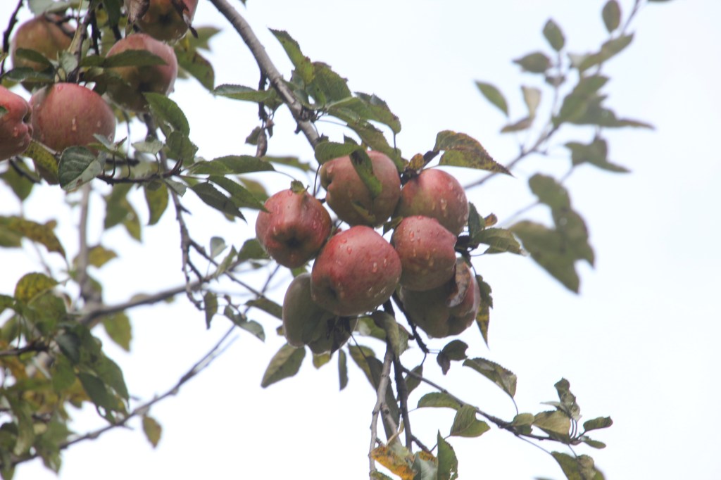
Fully grown red apples hung from the shoots and the tree was having a tough time keeping upright. The fruits were bathed in fresh morning dew! Weather was good with some sunshine and walking was comfortable. We continued to face sections of mud and had to tread these carefully. The trail was undulating, moving up and down gently. This is generally considered as “flat” by locals in these areas.

I kind of agreed with their assessment, in hindsight, now that I’ve seen the later sections of the trail. Clouds started hovering above again and we reached a section where the trail moved under an overhang of rocks. Water droplets kept coming down their edges dripping the trail below. It was difficult to skip these droplets and we got rinsed by them despite lack of a drizzle.

The trail continued along the banks of the Marsyhang di and we reached a place where we left the road to take a detour along a foot bridge. The trail was to short circuit the jeep road, eventually rejoining the road at a later section. The rest of the group was busy taking photographs, while I moved ahead of them and suddenly found myself walking alone. After crossing the footbridge, the trail moved up the slopes through multiple switchbacks though a dense pine forest. It was well above the road. For a certain time, I was alone on that trail, with no signs of rest of the group or for that matter, any other person. Did I took the wrong turn? I crossed a few locals who were on their way down. Asking them didn’t reveal much as they couldn’t understand my language and their answers were circumspect and terse. Nevertheless, I move ahead with the belief that mountain roads normally meet up somewhere. Though it was moist, walking through forest cover is always welcome.

Despite moving through the forest, we could hear the roar (somewhat muted) of the Marshyang di river. Eventually, the trail joined the main road once again and we reached Bhratang. The road through Bhratang was lined by apple orchards on both sides and we reached a farm house. It’s a place where people consider taking halts. Trees were full of fruits. There were trees of red as well as green varieties of apples. The orchards ran from the road, right up to the mountain walls that surrounded the valley on both sides. The lush green orchards with red and green fruits abundant in the trees, formed a contrasting backdrop against the dark clouds hovering above.
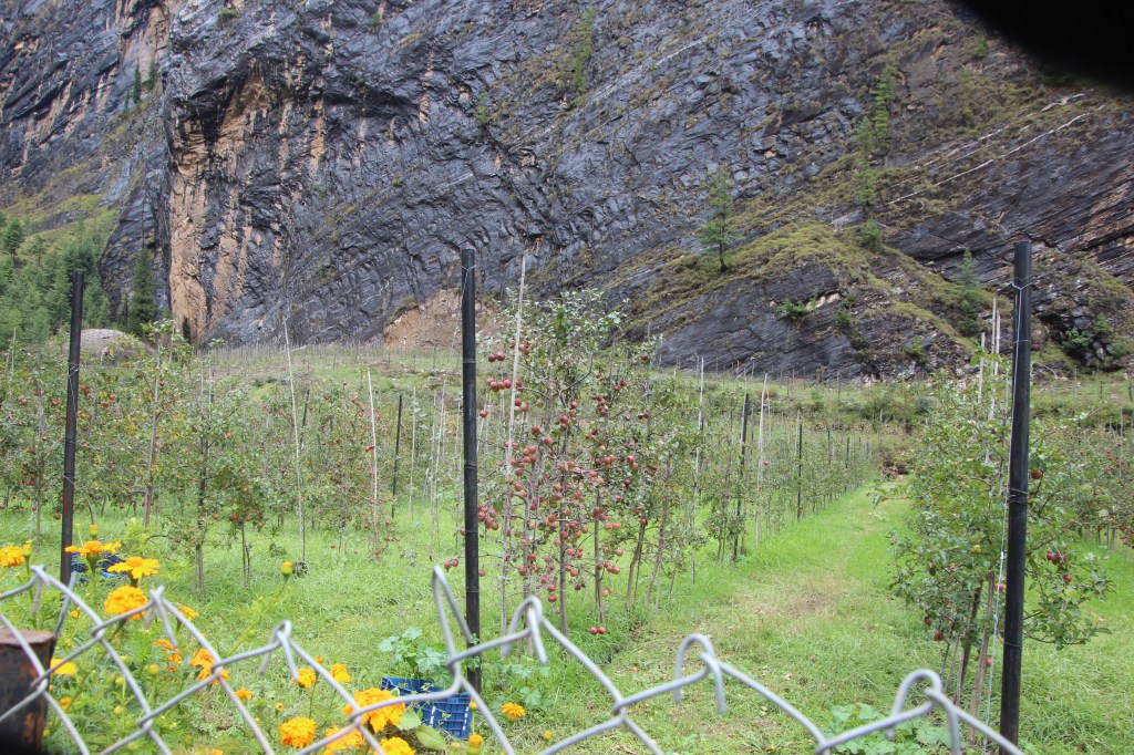
We stopped for sometime at the Bhratang tea house and bought some fresh apples. Moving ahead, we came across a view of the Paunga Danda, a smooth rock face, rising above 1500 m from the river. Local call it “Swarga dwar” or gateway to heaven. They believe that the spirits of the deceased must ascend the wall of this to reach heaven!

After crossing the orchards, the road moved amidst the valley and we were offered with another short route up the slopes allowing us to leave the jeep road. Though these are steeper, but short circuit the distance and offer much needed relief from the jeep road. They also move through dense forests. It was here, I once again found myself walking alone, ahead of the group. After sometime, the trail rejoined the road, where there was a tea shop. There were still no signs of the remaining members. So, I thought of waiting. There were members of other groups who passed by along another detour that moved up the slopes, giving another escape route from the jeep road. After about 10 minutes, my group members started making their appearance and I resumed my walk along with them. This second detour was shorter and we soon joined the jeep road in a flat section. Our guide informed us that Dhukur Pokhari, our lunch spot, was just about half an hour of walk from that point. It was a comfortable walk from that point and we reached the tea house. By that time, a steady drizzle had already started. As usual, we ordered our “Dal bhat”s and awaited their arrival.
The day before, at Timang, I felt cold during lunch. That prompted me to carry a jacket in my backpack. It was a jacket suited for higher altitudes, but I had no other jacket for lower altitudes. I put on the jacket during lunch. That gave some respite but I knew that I had to take it off before resuming walk after lunch. The dining space was big and we enjoyed resting there awaiting lunch. However, the drizzle outside converted to a steady downpour and we still had another two hours of walk to upper Pisang. We saw some jeeps plying on the roads. That implied that the blockages in the lower areas have been cleared. Lot of local Nepalese people visit Tilicho lake. They normally take jeep rides till Manang (some even beyond that, till Khangsar). From thereon, they walk to Tilicho base camp and then on to the lake. We saw some jeeps with locals carrying the Nepalese national flag.

After lunch, we resumed our walk. After sometime, the trail split with one track ahead towards lower pisang. But we took the trail that moved away from the lower track. That one moved up directly towards upper Pisang. Both upper and lower Pisang have tea houses and both the routes ultimately reach Manang. The lower route takes much less time and has less hikes but the upper trail offers much better views. We opted to stay at upper Pisang. Whether we take upper or lower routes to Manang had to depend on the weather. In bad weather, there’s no point taking the upper route as mountains won’t be visible anyways. As we moved towards the upper trail, we came to a lake (Dhukur pokhari) and went along the trail along its banks. Visibility reduced very much due to rain. Fortunately, the hike towards upper Pisang was not very steep. After a few bends, we came across a gate with mani wheels. After crossing the gate, we had to walk for some time before we could see the stone houses and tea houses of the upper Pisang village. We waited in the lawn of the first tea house, allowing our guide to reach and then followed along with him to our destined tea house.
We were allotted a three bedded room with an attached toilet. The room barely had space for three but considering the circumstances, it seemed a luxury. After reaching tea houses towards the end of a day, one part of our minds urged for some rest but the other urged to get the clothes changed as soon as possible to avoid cold. Always better sense prevailed and we went along with the latter. It was no exception here too. After settling in, we asked for warm water and started preparing tea. Snacks and biscuits came out of our bags and tea session was on. After tea, we went to the dining space, which was on the upper floor. We hung our wet shirts on the balcony. Later on, we took them with us near the fire place with the hopes of drying them. Climbing stairs proved difficult with tired legs but once we reached the dining space, we could spend the whole evening there, enjoying the warmth of the place. That’s what most people do. After dinner, we headed to our room. Sinceit was only 7 PM, we chose to play ludo. Niladri downloaded the game on his mobile and we enjoyed a few sessions of the game. It brought back the excitement of childhood among us and more importantly, helped to kill time as after darkness falls, there isn’t much left to be done in these remote areas. There are two routes to reach Manang. We deferred the decision to the next day, depending on the weather. Wi-Fi proved to be a good vehicle and so far, we’ve been able to keep our homes informed and that continued in upper Pisang too. We hoped to do the same till Manang at least, beyond which, it remained uncertain. We knew there were snow peaks all around the place, but we couldn’t get any glimpse due to the weather. We kept the game going for sometime and then slipped under the blankets. We were sleeping at 3310 m.

Hi Indranil,
This reminds me of our trek in Nepal in 1990’s. Dhaulagiri and Nilgiri viewed from 4000m on Annapurna, and the small planes flying below along the valley floor are memories I treasure. COVID stopped our trip in 2020 to Darjeeling Himalaya (we were packed and about to head to the airport). Perhaps another day …
Congratulations on your journey – keep well.
John Burgess
PS I really must digitise some film negatives from those days 🙂
LikeLiked by 1 person
Would like to see your snaps, please do.
LikeLike