
12th October
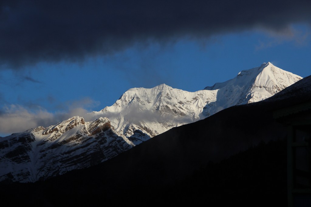
When we pulled the curtains on the sole window in our room before sliding under the blankets in the previous night, it was still drizzling. After the alarm went off in the morning, I slid the curtains to have a glimpse of the sky, but was disappointed to watch the clouds having an upper hand. Forecasts aren’t always accurate and they can be off by a day or two. While it doesn’t take anything off the forecasters, but that could derail our schedule entirely. We may reach a state where we might be forced to trade off Tilicho lake to ensure Thorong la stays on schedule. We went about our morning business as usual and packed our bags to keep them ready for porters to carry. As we ventured out of our rooms to go towards the dining place, we were in for a pleasant surprise. Snow clad slopes of the mountain peaks were visible on the horizon. Clouds gradually steered away and the mountains started to unfold. For the first time on this trip, the sun made it’s presence felt. The moon was yet to leave the stage, but morning rays of sun started to crown the peaks.

I went outside the tea house in my slippers to capture the moments as the sun started its journey up in the sky. Morning and dusk offer the best shades of color on snow clad peaks, but they change by the flip of the eyes.
After breakfast, we decided to visit the local monastery of the village. After leaving the lodge, the trail went up the slopes through an alley amidst the local houses. As it moved up, mountains opened up even more and our guide declared that we’d be taking the upper route (via Ngawal) to Manang. That boosted our hopes for the days to come. Our best wishes went to the forecaster who was right on the money. The trail reached to the premises of the monastery. It was a wide and open area with mountain views at display for 360 degrees. Now that most of the mountains removed their veil, our guide went about making us aware of their identities. Starting from extreme left in the corner, we could see Mt Manaslu, Annapurna IV, Annapurna II, III, Gangapurna, Mt Tilicho, many others in between and on the extreme right, towering above the village, was the Pisang peak. The family from New Zealand was enjoying and kids played and ran around the place. Bright sunshine added to their upbeat mood.


Despite enjoying the views, we had to cut our stay short and we headed back to the tea house, strapped our backpacks and hit the trail, amidst full sunshine, for the first time on this trip. It was to stay the same for the rest of it. The trail was flat as we exited Upper Pisang. As we went past the bends and looked back, the entire village of Upper Pisang lay in front of us along the slopes of the hills.

After sometime, the trail reached a place where some porters and guides assembled for gossip and smoke. I greeted them and went ahead when someone screamed from behind and pointed upwards. I couldn’t understand, but later realized that he was pointing towards a trail that moved up the slopes. I was about to take the lower route, which was wide enough for vehicles to ply, but it wasn’t the correct one. The trail that moved up, was narrower and moved through a series of steep switchbacks, right up to the top of the hill where we could see terraced roofs and stupas, all diminished in their statures. Looking at the route, it appeared daunting. That village at the top was Ghyaru. Going by what our guide said, beyond Ghyaru, a flat trail awaited us, which would take us to Ngawal, our place for lunch. After Ngawal, the trail would descend and the final stretch was a flat track to the town of Manang. The words “flat” and “down” sounded as bells to our ears. It all boiled down to this hike up to Ghyaru.

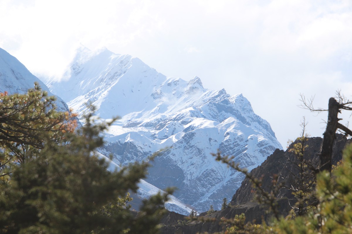
After crossing a bridge, we started on the hike. To be fair, the trail was divided into many switchbacks, generating many small milestones for us. Mountains of the Annapurna range grew in their stature as we moved up the slopes.


After every bend, we stopped to enjoy their views which kept changing. There were some shortcuts that stitched across the switchbacks, but the effort proved too daunting to be time savers. I gave up and resumed along the normal trail.

Fresh snow covered the slopes of the distant peaks. The last few days of weather heaped much of them along the slopes and as a result, we were presented with awe inspiring views! Its appropriate to say, days of darkness leads to light at the end of a tunnel.
Looking above, I could see many switchbacks ahead. The entire route above, was sprinkled with trekkers from other groups, at different stages of their journey. I stood for sometime to take a look (also give some respite to my lungs and knees) and it appeared as a snapshot of life where at any given point in time, different people are at different stages, some just about to start, some already underway and yet others, about to conclude! After crossing a few switchbacks, we came to a place where some trekkers assembled for some rest. One guy was trekking with a bare body. That drew a lot of attention from passers by, given the climate. Regardless of the bright sunshine, it was a bold act. A few more switchbacks took us to the doorstep of the monastery of the Ghyaru village. The lawn of the monastery offered a bird’s eye view of the valley, the Marshyang di river valley. Beyond the valley, rose the mighty peaks of the Annapurna Himal. A huge Himalayan Griffon vulture was flying high up in the sky. I took some moving shots following the bird on its trail, which provided some wonderful shots in the backdrop of the surrounding snow clad peaks.

After spending some time at Ghyaru, we resumed on our trail, which went through an undulating terrain. Walking was now comfortable. We treaded along nicely in the warm and bright sunshine. After crossing a few bends, we came across an entrance gate adorned with mani prayer wheels. The trail went through the gate and we could see it’s entire serpentine trail along the mountain slopes which ended in a distant village with a few tea houses. “Ngawal” someone declared from the group that was travelling beside us. It lay leisurely along the barren slopes of the mountains.

It was a picturesque village and the closer we moved towards it, the more we loved it. After sometime we reached the tea house and settled in its dining room. “Dal bhats” were ordered. The valley around was wide open and surrounded by mighty snow clad peaks of the Annapurna Himal. We basked in the warmth of bright sunshine amidst the picturesque grandeur of nature.

After lunch, we hit the trail once again. The section of the rail we were now treading upon, was paved with concrete and to our relief, it gradually started heading downwards. During our lunch at Ngawal, strong winds forced me to put on my jacket, which now started to prove cumbersome and I had to take it off. Vegetation reduced drastically after Ngawal and barren and rugged mountain slopes became more frequent. Years of corrosion by strong winds flowing through the valley carved out awe inspiring sculptures out of the rocky walls. At times they appeared like huge termite mounds.

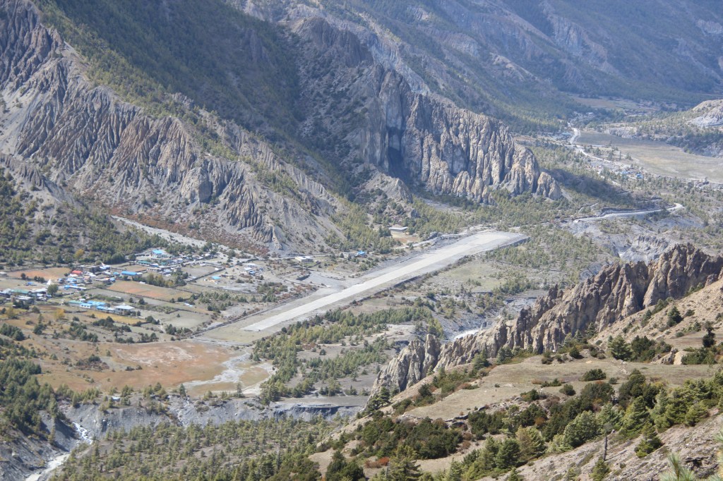
As the trail moved down, we could see the other track coming from lower Pisang. Beside the track, lay the Humde air strip, which serves as a local airport for Manang. The airport also has a helipad, an important piece of infrastructure which supports Helicopter rescue system which frequently comes to use in these areas of high altitude to evacuate trekkers and mountaineers to lower regions or to cities of Pokhara or Kathmandu for urgent medical treatment. High altitude mountain sickness or painful sprains or fractures are often causes of such rescues. Nepal has a well-oiled rescue system supported by such helipads in these areas or even higher reaches.
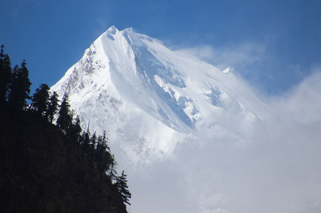
As our trail reached down to meet the other track from Lower Pisang, forests with sparse vegetation re-appeared. The afternoon sun cast its glows over the trees and we walked over a flat trail meandering through such forests on both sides. Beyond the tree line, mighty snow peaks prevailed. They came forward to meet the trail as we moved closer to Manang.

The snow walls made a contrasting backdrop for the low lying pine forests with their tops rinsed with golden afternoon sunshine. Our walk was interrupted repeatedly with many such views and shutters kept rolling on relentlessly.

The closer we moved towards Manang, the more imposing postures the snow peaks assumed. We had ample time to go at a leisurely pace. The sunny weather played a perfect foil to this enjoyable walk.

The trail passed through the village of Munji and another 2 kms of walk took us to Bragha, the village before the town of Manang. We saw the trail towards ice lake that moved up along the slopes. Ice lake was one of the available options for day hiking for the next day which was supposed to be our acclimatization day at Manang. After another 20-25 minutes of walking, we came into a wide open valley. Numerous yaks grazed around the field amidst the backdrop of the distant mountains.

After moving past the fields of grazing yaks, the trail gradually moved upwards through a gate that welcomes the trekkers to Manang. As we moved along, we went past the jeep stand, the termination point of the vehicles that ply on this route from Besisahar. This gravel road that goes all the way from Manang to Besisahar is a lifeline for the villages that dot the route. Hotel Tilicho was our slated tea house. It was a grand tea house. It had its own bakery and coffee shop, apart from the standard dining space. It was a double storeyed tea house with a square open area surrounded by bed rooms on all sides. We were allotted a three bedded room at one corner. The room had enough space. We settled in the room. Dhananjoy headed for a hot shower. After settling in, we went around the village to have a walk. The sun was still out. Wi-Fi allowed us to make calls to our respective homes. We informed that this was probably going to be the last place with such facilities. The owner of the tea house was also not sure about what to expect at tea houses at Tilicho Base camp, Thorong Phedi or even at places like Sree Kharka or Yak Kharka. That news was received with some nervousness at our homes. It meant we were going to be out of reach for next four to five days till we reached Muktinath on the other side of Thorong La. Fortunately, we were proved wrong with our assumptions. We had a feeling of home at Manang and that had a lot to do with the facilities at the tea house and also with the fact that for the first and the only time during our trek, we’d spend two nights at the same tea house. We made enquiries about the route beyond Manang in both directions (Tilicho lake as well as Thorong La). Tilicho lake still had a lot of snow on the route, but Thorong La was clear and many people have crossed it over the last few days. After dinner, we slid under the warm and comfortable blankets. We were sleeping at 3519 m.

2 thoughts on “Around Annapurna – Reaching Manang”