

18th October
We were fortunate enough to get three lower births (yes, births) as we were the first to enter the room. Later in the night, the other births on the upper floor were occupied by three other travelers. Space was crammed but under the conditions, the accommodation couldn’t have been better. Sleeping under blankets within a room (and not a tent) is in itself a luxury at these altitudes. We paid up our bills after dinner on the previous night to allow us to start immediately after breakfast. Throughout the time when we had our breakfast, Thorong la played in my mind. The dining space was warm with many travelers roaming around, some still having their meals, others, about to embark on the hike.
After breakfast, just before we were about to hit the trail, our guide reran the dos & don’ts. We were strictly advised to stay together. While it didn’t mean walking side by side (it wasn’t at all feasible on this trail), it did mean staying within “calling” distance with each other. After we moved outside, a chilling wind greeted us which shook us to the bones. A serpentine line of torches moved up the slopes. Unlike the route to Tilicho base camp, the trail was entirely covered with snow right from the beginning. However, the slope wasn’t steep to start with, at least. Numerous stars studded the dark sky. We’ve crossed two mountain passes of similar height before. Both of them in Nepal. The first was Cho La, on our way to Gokyo from Lobuche in the Everest region. The other was Larkya La, the highest point on the Manaslu Circuit Trek. Crossing the latter was also a long day & we expected this to be a similar experience. The descent too, similar to that of Larkya La, was expected to be steep. In case of Larkya La, the entire descent was through a rock fall zone. I wasn’t sure about the terrain in this case. Another factor weighed on my mind was the expected amount of snow on the other side. For the moment, I swept those thoughts aside & focused on the hike. The dark silhouettes of the surrounding mountains appeared gigantic. Our boots sunk deep into the snow. With the help of our head torches, we looked for footmarks of other travelers and tried to follow them. Fortunately, the snow was dense and we could get grip on the surface. The idea was to cover as much ground as possible before the sun came out. While we walked, we felt perspiration within our body, but the moment we stopped for rest (which was necessary to fill our lungs), biting cold sent shivers through the body. Apart from our layers of warm clothing, sips of warm water were also crucial to keep our blood circulation going. Darkness started to dilute and edges of the surrounding mountains started becoming clearer. We could now see a light glimpse of the trail ahead. Metallic poles indicated milestones at regular intervals and there were a series of them. The trail had many lower summits, each one of them decorated with strings of prayer flags. Whenever any of them appeared on the horizon, some of us would ask the guide whether that was the pass and answer was an emphatic “No”. I was aware of this phenomenon. Thanks to many blogs & videos on the internet, I was aware that there were many “false” summits on the way up to the pass & people often get frustrated by these & it could add to their fatigue. By this time, the sun was fully out in the sky. There wasn’t any patch of black anywhere on the trail, which was only recognizable by a series of footmarks. Series of travelers trekked along the path. It was a moving line with ever diminishing size of humans. The last visible prayer flag at the distant top appeared as a miniscule pole, but even that wasn’t the top.

We focused on the next pole nearby. Every step had to be dragged on, partly because of the fact that our shoes got submerged, partly also due to the altitude & cold. The air around was a tad caustic and we felt thirsty after a handful of steps. After sometime we reached a tea shop en-route the top. No one expects to find a tea shop at such altitudes, but that’s Nepal for you. A much needed cup of tea to get our blood circulations going, was more than welcome. We found a similar tea shop on our way to Larkya la during our Manaslu Circuit Trek. We made our way into the shop and ordered tea. The desire was to spend some time in the warmth of the shop amidst other trekkers, but an eye had to be kept on time. The top was yet to be reached (about forty percent of the track still remained).

We ventured out of the tea shop and resumed our hike. The hike wasn’t steep and started leveling out. It was an indication that we were approaching the pass. The sky was clear and bright sunshine bathed the slopes all around. Cold wasn’t biting anymore with the sun shining bright on our backs. Fortunately, there wasn’t any wind. Our guide declared that the pass was nearing and we could see the prayer strings hanging from a distant pole. Though initially, I wasn’t convinced, but I saw many moving figures around that place, which indicated that he was correct. With increased hopes, our walking speed increased and after a stroll on the snow, we reached there.
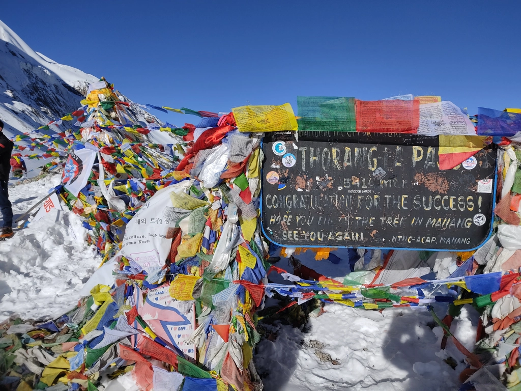
Many travelers were already there, taking snaps against the backdrop of the board that depicted the name and height of the pass. We were standing at 5416 m. All of us were ecstatic about reaching the highest point of the trek. The Thorong la was a junction that connected Manang with the Mustang district of Nepal. Both of these were arid and dry, lying in the rain shadow areas of the Annapurna massif. However, Mustang bore a drier look. The mountain ranges of Mustang spanned throughout the distant horizon. The track gradually moved downwards on the other side of the pass. We’d be treading that path on our way down to Muktinath. The trail down was also covered with snow, leaving any doubts, whatsoever. To our surprise, there was a tea shop at the top as well! We took turns to take snaps (both individual as well as with the group) at the Thorong la.

The time came up and we started our descent. The track moved down gradually in its initial stretch. As soon as we started our descent, we felt the gusts of strong wind which threw up puffs of fresh snow from the trail. I walked carefully, once again, tracing the tracks of earlier travelers. Other travelers crossed by, most of them having the support of crampons or micro spikes, while I treaded on carefully.

Slopes were still gentle but wind was picking up pace and at one bend it blew off my hat which went down the slopes within a blink of an eye. Dhananjoy and Niladri went ahead and pretty soon were out of my vision. The slope started to increase and I also felt the ice harden under my feet. The shoes started to give minor slips and my steps became more circumspect. One has to move at a minimum pace to avoid generating more than desired pressure at a single point, which could result in slipping down the slopes. Interestingly, some groups came up the slopes from the other side. That was interesting as normally, people do not cross the Thorong la from Mustang as the hike is much steeper and takes longer. Some of them cautioned the guide (who was walking besides me) that the trail ahead was somewhat risky. I saw an alley going steeply down amidst the snow. Reaching at the top of it, I realized why he said so. The ground was totally covered with ice which was showing cracks and water trickled from them. For once, I thought of lying down on my back and try to slid along but the guide advised against doing it. Despite taking careful steps while going down the slope, I slid a few times and regained my steps. It was a long ordeal before I finally negotiated the slope to reach a junction. The trail beyond that point moved on different grounds. It wasn’t hard ice, but fresh, loose and powdery snow which offered minimal grip. I could see Dhananjoy and Niladri treading ahead carefully. Observing their steps, it became apparent, they found it difficult to walk stably. The first step that I placed on the snow led to a slide and I slid down considerably. The guide was prompt enough to arrest my slide by hold me by my armpit. To complicate matters further, strong winds displaced snow under our feet trying hard to dislodge us. The guide sought the help of one of the porters, who, by that time, had already crossed over to higher grounds beyond the snow. He was considerate enough to heed the call and came down. Both of them gave me support and I somehow managed to tread the shaky grounds to reach beyond the snow. Travelers rested under a shed and I rejoined Dhananjoy and Niladri. I was still breathing hard. We spent sometime to exchange our experiences but to our relief, one of the guides from other teams declared that this was the last stretch of snow. Beyond this point, the ground was rocky and dry. It was still steep but devoid of snow. I quick sneak into the trail ahead, revealed he was correct. That was another huge sigh of relief for me on this trail (the other one was when I discovered a wooden bridge that joined a yawning crack on our way back to Shree Kharka).

We still had a long way to go down, but now I could walk freely, at my own pace. The track was full of switchbacks. The trail was strewn with stones and boulders. One had to walk carefully to avoid a slide, but it was much better than the rockfall zone at Larkya la. I could see Dhananjoy and Niladri as small creatures, making their way down and beyond them, the tea houses of Phedi were now visible. I took sometime to look back at the trail which we covered till now and thanked nature that Thorong la was behind us. Easy grounds awaited us on our way down. I could feel the fatigue in my legs. The upper half of it pained as I made my way down, but I was happy. There are times when pain is sweet! I made my way through the maze of switchbacks to reach the tea house at Phedi and spread my arms on a chair. Niladri and Dhananjoy were already seated. It was 2 PM. We had enough time to relax while our lunches got prepared. I dried up my jacket in the sun. My knees trembled as I attempted to move. Lunch took long to get served, but there was nothing to complain as we had ample time. The downhill walk from the tea house to Muktinath was to take another two hours. From Phedi, the trail moved towards a valley and once we reached there, the ground was flat. It feels so comfortable to walk on flat grounds on such high altitudes. For the first time in this trek, we walked together as we meandered through the valley to join a road that led us down to the town of Muktinath.

We could see the domes of the Muktinath temples, considered holy by both Hindus and Buddhists. We followed the steps down to the courtyard of the famous Muktinath shrine. A wide panorama of Mustang mountain peaks were visible from the courtyard which was full of devotees, many of whom bathed in the small pond in the middle of it.

The most prominent among the mountains visible from Mustang was Mt Dhaulagiri, the seventh highest mountain the world. After spending sometime at the temple courtyard, we made our way down the steps that descended towards the Muktinath town.


It was a long series of steps that led to the area of the tea houses. Some of them turned us down as they were full. We finally found one and reached our allotted rooms. Much to our delight, warm showers were available and we made full use of it. Calls were made to our respective homes informing them of our successful culmination of the trek. The food tasted delicious and we spent our last evening of the trek with peace and leisure. Vehicle was booked by our guide, which would drive us to Pokhra, the next day. We started the day at 4800m, reached 5416m and then descended to 3762m.

4 thoughts on “Around Annapurna – the Thorong la, descent to Muktinath”