

Gorakshep, Kalapathhar, Dzongla
7th May, 2016
We left the last traces of green on our way to Lobuche. Now it was all boulders, rocks & dust (or so we thought). We left our lodge in the morning and went past others. The trail moved upwards and we found ourselves walking along the edge of what appeared to be a river of boulders. It really looked as if it was the bed of a river that had dried up long ago, but the track was clear enough. There wasn’t any path per se. One could only gauge the approximate route by following other trekkers and guides. The entire route was about climbing up a heap of boulders, coming down only to climb up again. Mountains on both sides were coming ever closer to us as we moved on. It wasn’t a clear weather. Clouds covered the top of the snow peaks nearby. We could see rivers of snow and ice coming down their slopes and merge into the river of boulders. The sight all around was that of destruction and debris and yet so beautiful.

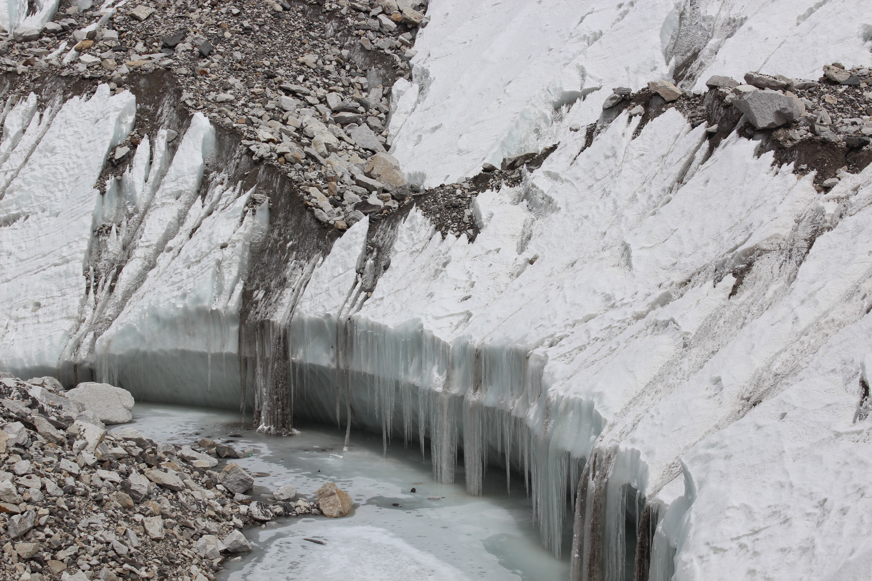
It was apparent that the landscape we were looking at was very unstable and the contours & alignments could change in moments. What must have gone through this region during the devastating earthquake of 2015. The mere thoughts sent shivers down my spine. What appeared to be a river of boulders, started to show cracks which were white in color with tinges of blue. Width of such cracks gradually increased. We realized what we thought to be a river of boulders, was actually a glacier with tons of ice accumulated over many years but its surface was camouflaged with rocks and dust.
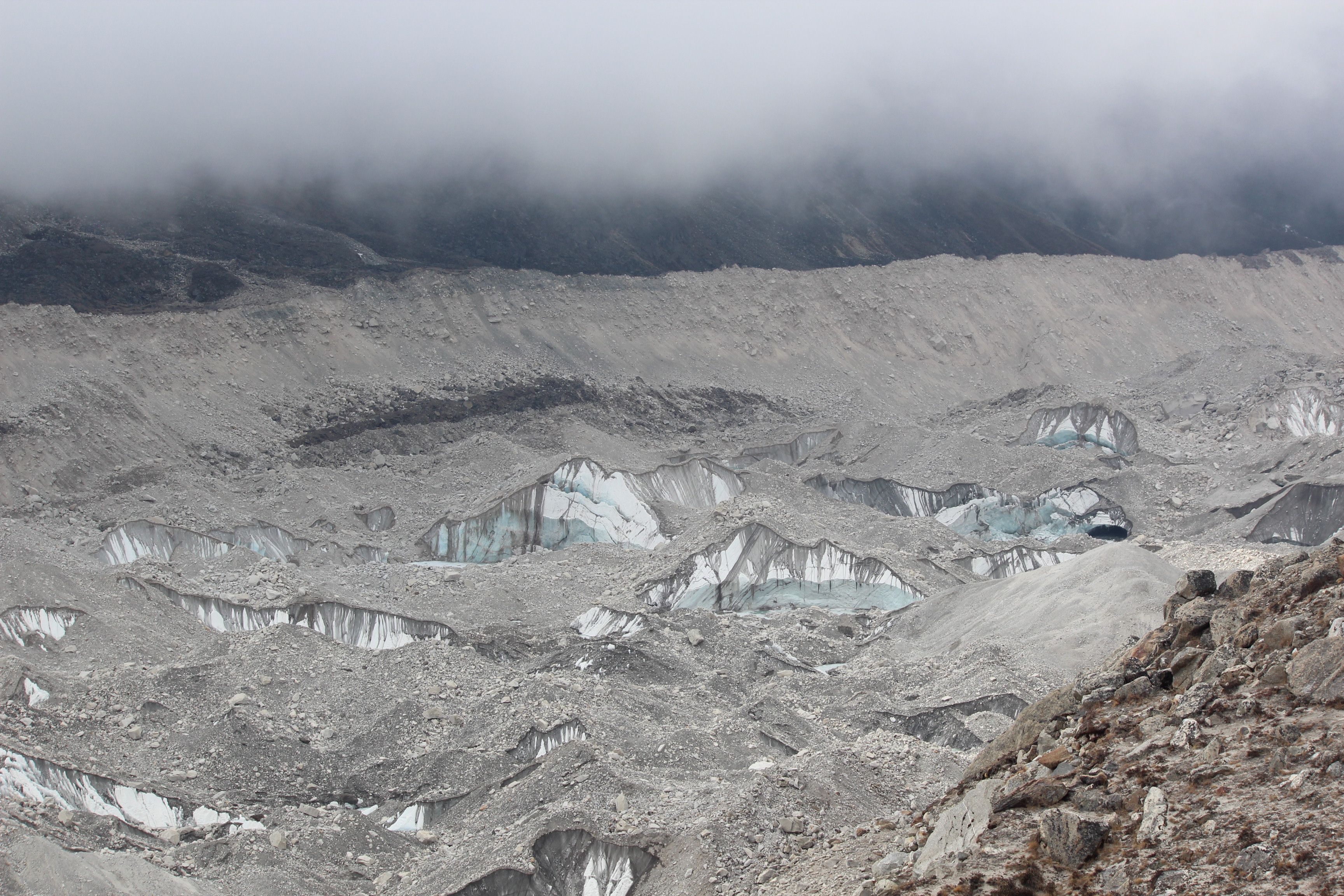
As we moved towards Gorakshep, such cracks increased in their frequency and width. The entire bed was dotted with cracks and pools of ice. The edges of the cracks around such pools were filled with frozen icicles hanging from the roof. We knew at once that we were walking along the edge of the famous Khumbu glacier that is formed by the ice and snow draining down the slopes between Everest and Lhotse-Nuptse ridge. It is the world’s highest glacier and it originates in the Western Cwm near Everest. The name was familiar to me thanks to the abundant literature about Everest expeditions and treks. No such description can be complete without a mention of this glacier and the large Khumbu ice-fall at its source. All members of the group were very excited as they kept taking snaps. We’ve heard so much about the glacier and reaching at its base meant Everest wasn’t far behind. It was there, but hidden behind Nuptse. Its an irony that one cannot see the Everest summit from its own base camp! We kept plodding on for about 2.5 hours till we reached the top of a hill. From there we could look down and see the lodges that formed the village of Gorakshep.

There was a vast stretch of flat and sandy area just beyond the lodges. At the edge of that area, steep walls climbed up the mountains and one could clearly see a track of thin line moving up the slopes. That was the trail to Kalapathhar, our destination for the morrow.
Gorakshep is actually a frozen lake bed at about 5130 m covered with sand. In the 1952 Swiss expedition (the expedition just before the first ever successful British expedition in 1953), Gorakshep was used as the base camp. From next year on, the base camp on the Nepalese side moved to where it currently resides. We took a breath or two and gradually descended the hill to reach our lodge. There was bright sunshine but clouds covered the mountain tops. We entered the dining space of the lodge which was very similar to every other lodge in the route. It was a long rectangular space at the center of which there was the chimney. That’s where dried yak dung gets burned to generate much needed warmth after the sun goes down. The chimney opens beyond the roof of the lodge so that all the smoke gets exhausted outside while leaving the place inside warm enough to sustain at this altitude. After we were allotted the rooms, we kept our backpacks and headed for the dining space to have our favorite honey, lemon tea sprinkled with pieces of ginger. There wasn’t much time for leisure and we ordered our lunch as we still had to travel almost the same distance after lunch to reach the Base Camp and come back here before the sun sets. I settled for mashed potatoes, while Niladri and Dhananjoy went for bread and omelets. Siddhhartha da was not eating well as he was suffering from indigestion for last few days. We tried to persuade him to gobble down some more as it was crucial to eat and drink enough to prevent high altitude sickness from creeping in. We mused around as we had our lunch and then it was time to hit the trail again. For the first time on this trail our backpacks were off our backs and we just had to carry our own bodies and bottles of water. We moved along the bed of loose sand that covered the flat surface and then moved upwards to reach the top of the ridge beside the Khumbu glacier once again.
We were on a trail dotted by huge rocks and boulders. The glacier was ever nearer and we could now see its trajectory filled with gaping cracks and cave-ins that exposed the underlying frozen ice and the glacial pools. The place around us gave enough evidence that it was not meant for human habitation and their presence was forcefully thrust upon the mountain. After about 2 hours of walk, the dusty glacial bed gradually gave way first to small and then large towers of ice and fresh snow. The bed was not covered with dust and boulders but with dazzling white towers of ice with tinges of blue. That told us were approaching the (in)famous Khumbu ice-fall.

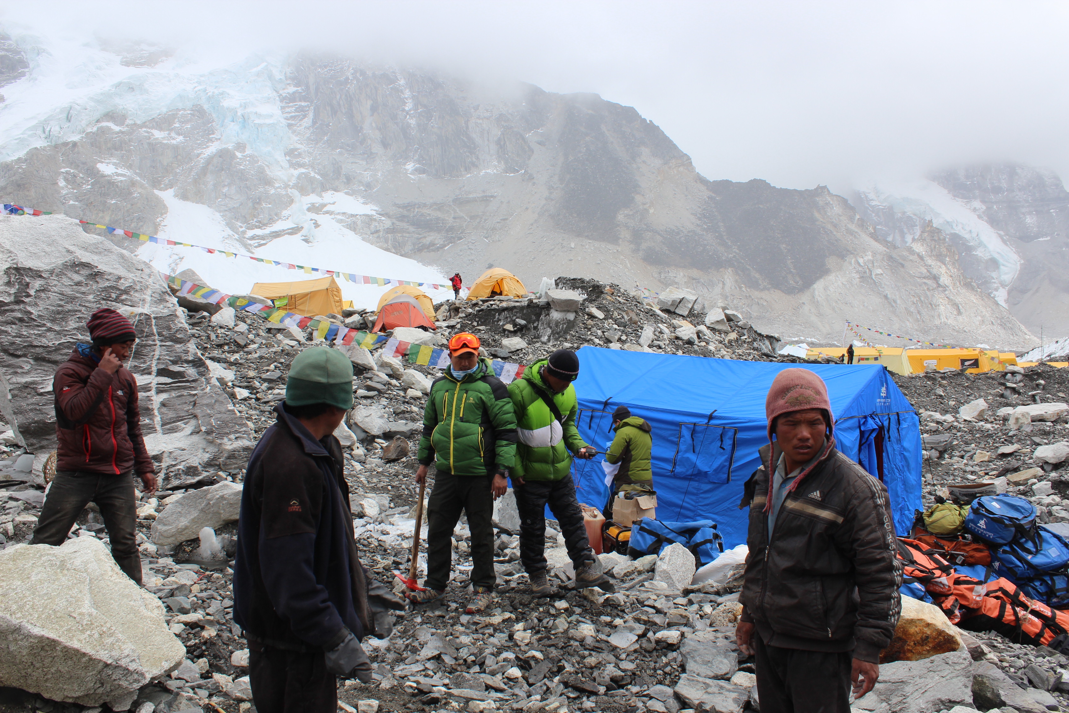
Dhananjoy attracted our attention towards a faint yellow object in the distant horizon amidst ice on the glacial bed. As we moved along, the object kept growing in size till we recognized it as one of the many tents pitched on the bed of the glacier. They kept growing in numbers dotting the entire landscape, some were blue and others, yellow. They were the tents of the numerous expeditions attempting to scale Mt Everest from the most frequented South Col-South East ridge route.

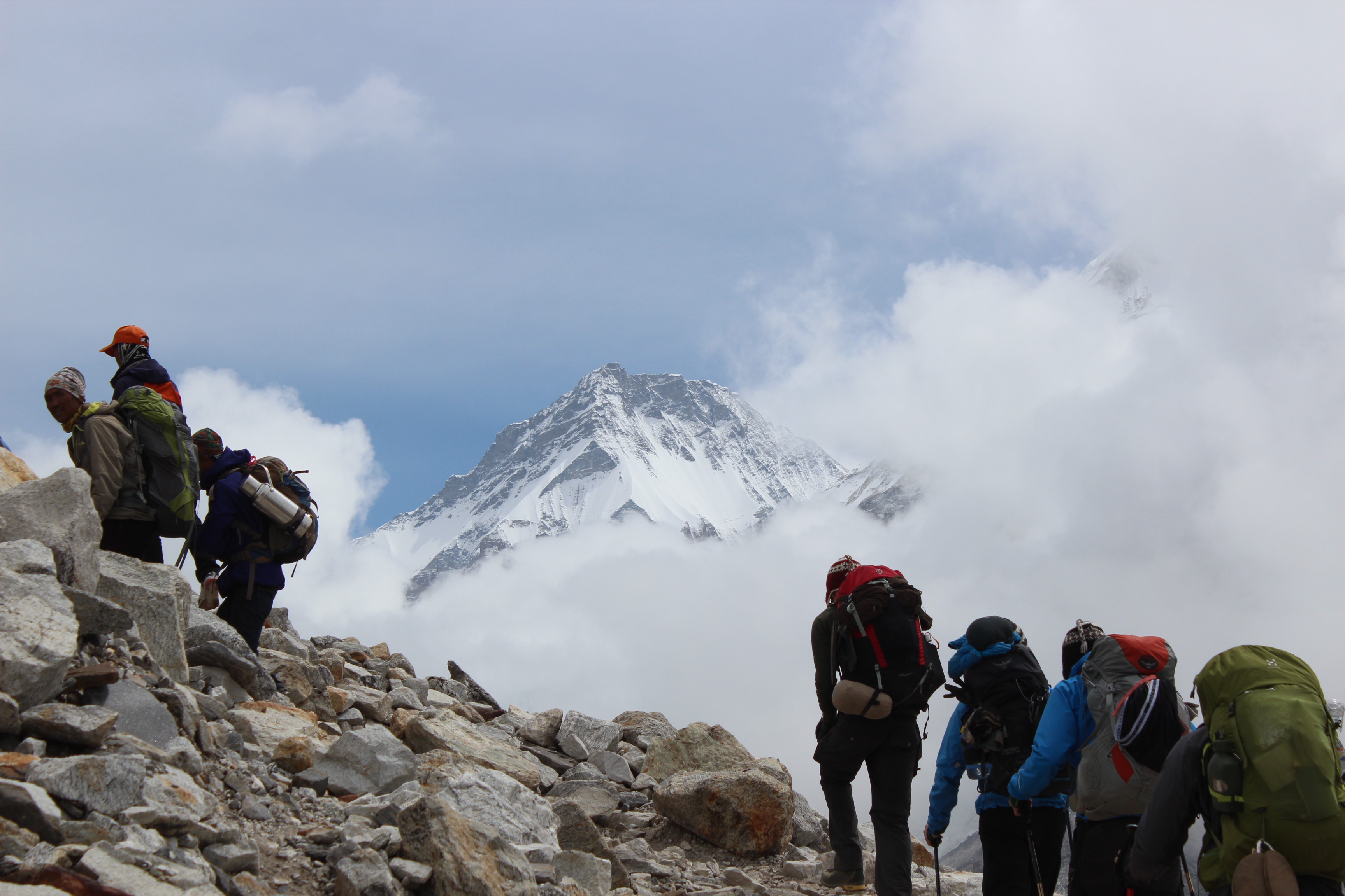
We reached the end of the ridge from where the trail moved down towards the bed of the glacier. We could see the entire area dotted with hundreds of tents, numerous porters and Sherpas from different expeditions. The peaks of Pumori, Khumbutse and Nuptse surrounded the entire area but they weren’t visible because of the clouds. We descended the trail to reach right at the middle of the “township” called Everest Base Camp. We were finally there!
If someone expects to be in a secluded place amidst nature or to find one alone with just the mountains, then Everest Base Camp is not the place to be in. With all its natural beauty and the amazing landscape, it was everything else, but secluded. It was a place bustling with activity.
We learnt later that there were as many as eighteen expeditions attempting Everest in the summer of 2016 from the Nepalese side. Everest has two base camps. The south base camp is in Nepal at an altitude of 5364 m, whereas the north base camp lies in Tibet at an altitude of 5150 m. These base camps are the places where the expedition teams lay siege for about two months. During this time, they take on multiple voyages up the mountain only to come back down to the base camp. Each voyage takes them to successively higher camps on the mountain. They are called acclimatization sorties and are meant to get the body adjusted to the lower levels of Oxygen higher up on the mountain. It is said that the summit only has a third of the amount of Oxygen that is available at the base camp. Finally, they take up the final ascent, which is called the summit push. Interestingly, in Nepal, the same site serves as the base camp for expeditions to Pumori and Lhotse (and potentially to other neighboring peaks), but it is Everest that has stamped its name on the base camp! If mountains were humans, then Lhotse might well have refused entries to its interior in protest against this humiliation. Fortunately, for the climbers, they are not!
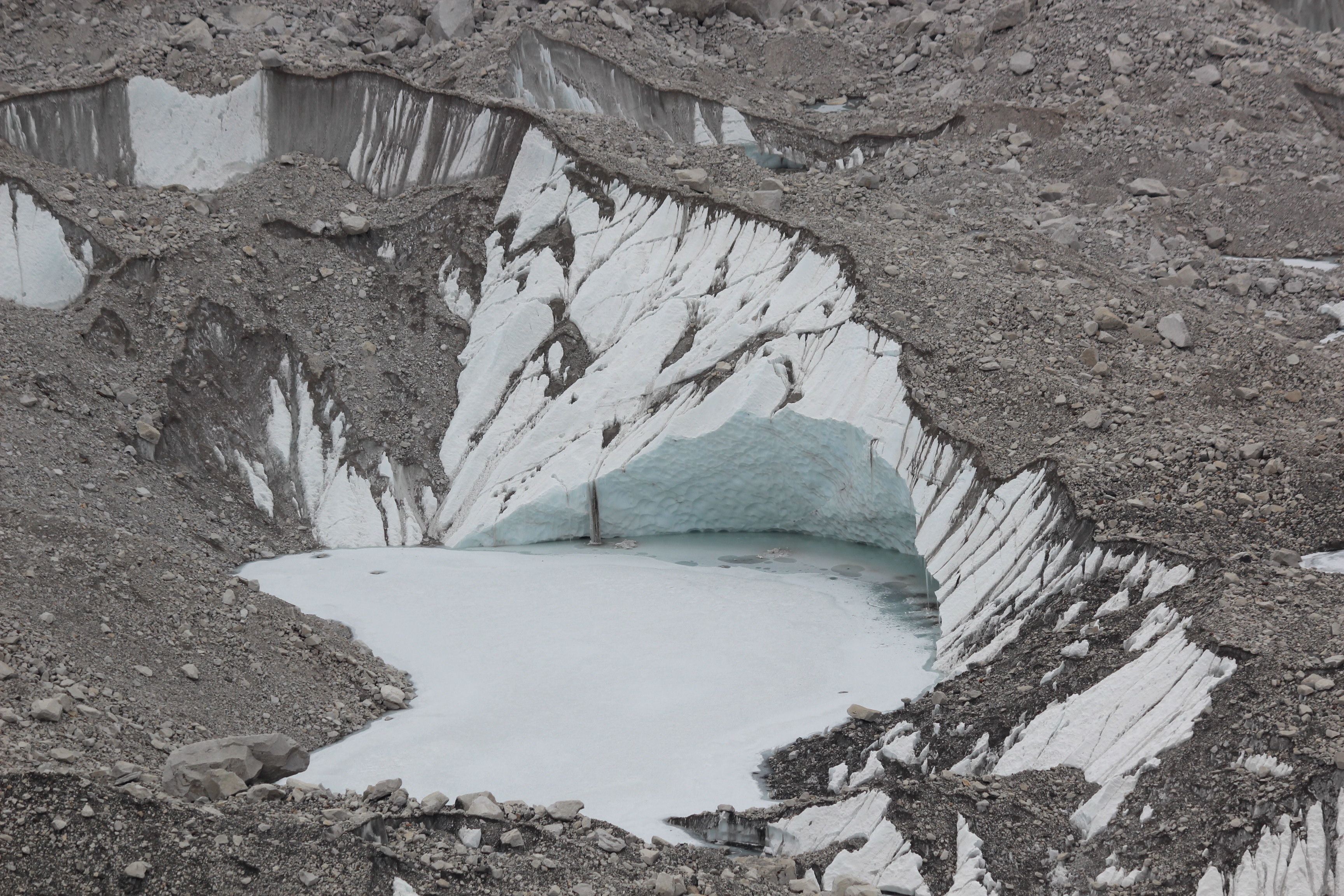
We were (and in fact, everybody else was) standing on top of the hardened ice of the glacial bed. The rocks and dust that covered its surface, gave a false impression of standing on rock surface, but a few kicks on the floor removes the dust and reveals the hardened ice below. In fact, the entire base camp is housed on the bed of Khumbu glacier. We were now standing at 5364 m above the sea level. We were standing on the floor of a huge amphitheater surrounded by the huge swathes of ice coming down the slopes of Pumori, Nuptse, Khumbutse and others. As far as our eyes could see, the entire Khumbu glacier was dotted with innumerable tents of the different expedition teams.

We went till the edge where the hard ice of the glacier gave way to random, uneven & often precariously placed masses of ice with a maze of tracks zigzagging through them. That was the Khumbu ice-fall, the first hurdle to overcome for anyone attempting to scale Everest from the Nepalese side.


I was gazing at the ice-fall when I noticed a few moving black spots amidst the towers of snow and ice. They were some of the climbers who were traversing through this maze of ice – one of their practices as part of their summit attempt.
This apparently beautiful ice-fall has proved to be the deathbed of way too many climbers and Sherpas over the years. As the Khumbu glacier moves with speed over the uneven rocky bed, huge masses of ice and snow that accumulates over it, splits up into cracks and crevasses. It results in creation of towers of ice with varying sizes and proportions. These are called seracs. Some of these are as high as multi storeyed buildings. These towers are very unstable and can collapse without any indication whatsoever. The first leg of the South Col-South East ridge route goes through a maze passing between and underneath such seracs. As the day bores on and rays of sun gets more intense, these become more unstable due to melting of snow at their bases. Climbers always try to cross the ice-fall early in the morning (they need to cross it multiple times during an expedition). The ice-fall claimed its first victim in the form of Jake Breitenbach, one of the members of the famous American expedition team of 1963. Though the expedition began with this fateful incident, it turned out to be one of the most successful in the history of climbing of Everest. Apart from placing the first American on the summit of Everest in the form of Jim Whittaker, the expedition also carried out many research works related to effects of high altitude on human physiology. However, the greatest feat of this expedition was achieved by Thomas Hornbein and Willi Unsoeld who became the first ever mountaineers to ascend Mt Everest by the West Ridge route. By the time they reached the summit, it was very late and they thought their best bet was to cross over and descend down the South Col-South East ridge route. Which they did and became the first ever mountaineers to traverse Everest.
On 18th April, 2014, a serac collapsed, triggering a huge avalanche burying sixteen climbing Sherpas in the Khumbu ice-fall.
At the start of the climbing season, every year, a team of Sherpas take up the task of establishing the route through the ice-fall to be taken up by subsequent expeditions. The route through the ice-fall changes every year and this team of Sherpas (quite aptly named “Ice-fall Doctors” by the famous climber Rob Hall) have the dangerous task of traversing the ice-fall, placing aluminium ladders over the gaping crevasses and roping up the high slopes. At the end of the season, they have an equally dangerous task of cleaning all that to take the ladders and ropes back to be used in the following season. The route thus established, is treated as a toll road of sorts. Every expedition has to pay a sum to this team of Sherpas before they traverse the route. Initially, this was slammed by some climbers as a practice of commercializing something which was essential for the safety of expeditions. But later, they came to realize the risk and danger involved in this task and agreed to it.
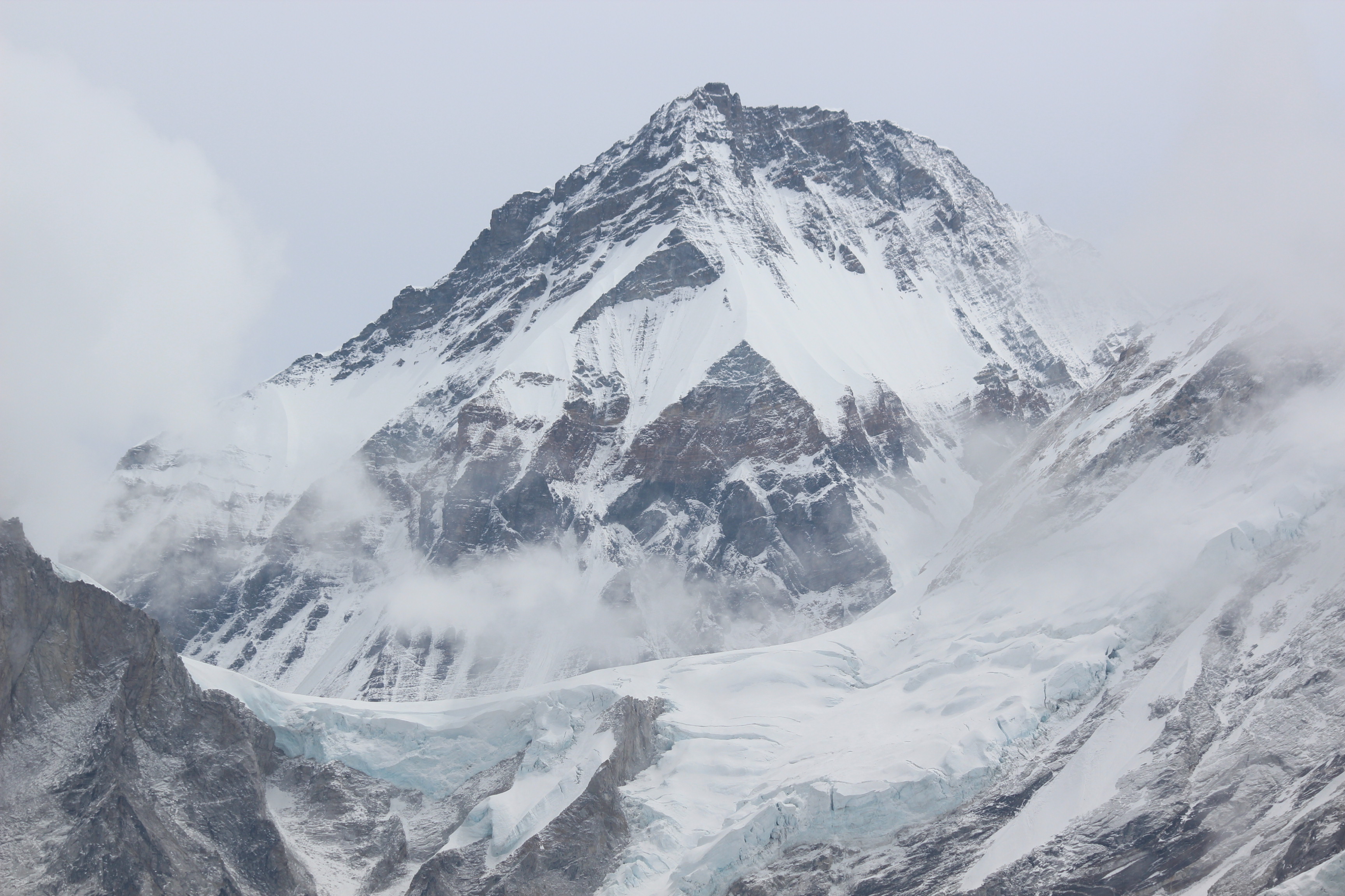
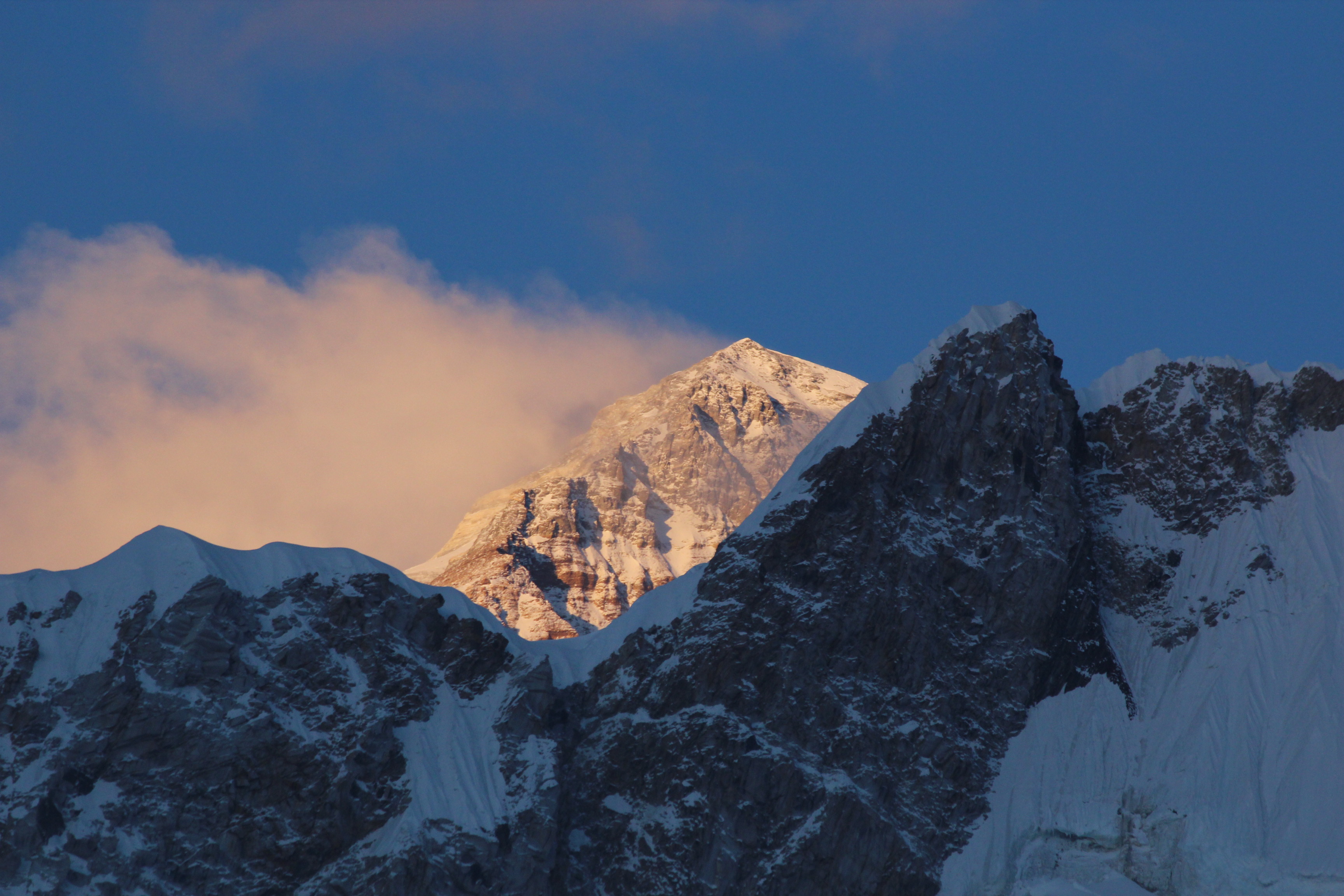
After spending sometime, we then turned around and started moving up the edge of the glacier to reach the ridge from where we descended earlier. Guide Raju waited for us there. The trail back to Gorakshep now appeared to be mostly flat and downhill. When we reached there, the sky cleared up suddenly and the fading rays of the sun bathed the peaks of Nuptse and Everest (peaking behind the Nuptse wall) with gold. I wished if we could be at the top of Kalapathhar at that moment. However, the view we were presented with was no less spectacular. The peaks around and in front of us appeared as a gold mine.


As the sun started setting, the color gradually turned scarlet, then red before turning white after the sun went down. We went to our beds earlier than the other days as the next day, we’d have to start our ascent to Kalapathhar as early as 4.30 AM.

One thought on “In the land of the sherpas – Everest Base Camp”