
14th October
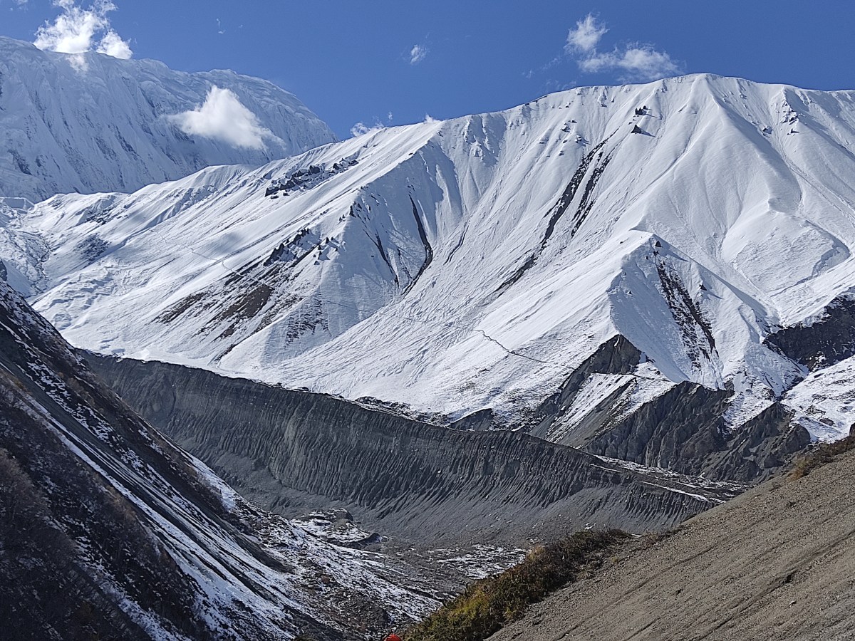
Bright sunshine greeted us the next morning. The day was critical as it would take us to Tilicho base camp. It is a critical section of the route and a large part of it goes through a land slide area. The mountains are dry and rugged in the area that bears more resemblance to Tibet than Nepal, since it lies entirely in the rain shadow area of the Annapurna range. The trail moves up and down steeply in certain sections where gravels and pebbles are abundant. The slopes have big heaps of rocks. Endless erosion caused by strong winds and snow over years have cut their edges morphing them into strange shapes and architectures. At times, they appear as huge termite heaps. One has to keep a constant eye on the upper slopes and cross the area as fast as possible under the circumstances (speed is a scarce commodity in such altitudes). The vigil is required to watch out for streams of rocks and pebbles that keep coming down and can dislodge the travelers any time. In their least pervasive form, they can cause damage like fractures. Even a small pebble coming down the slopes from high above, can wreak havoc because of its momentum. Such streams of rocks can be generated simply by winds sweeping the surfaces or herds of Himalayan Blue Sheep, which roam around in the high slopes. They move around swiftly while navigating the slopes. Fights too, are common among competing males for drawing attention of females. All such activities can cause problems for trekkers navigating the trail. After all, we’re intruders in this area and they’re the original claimants.

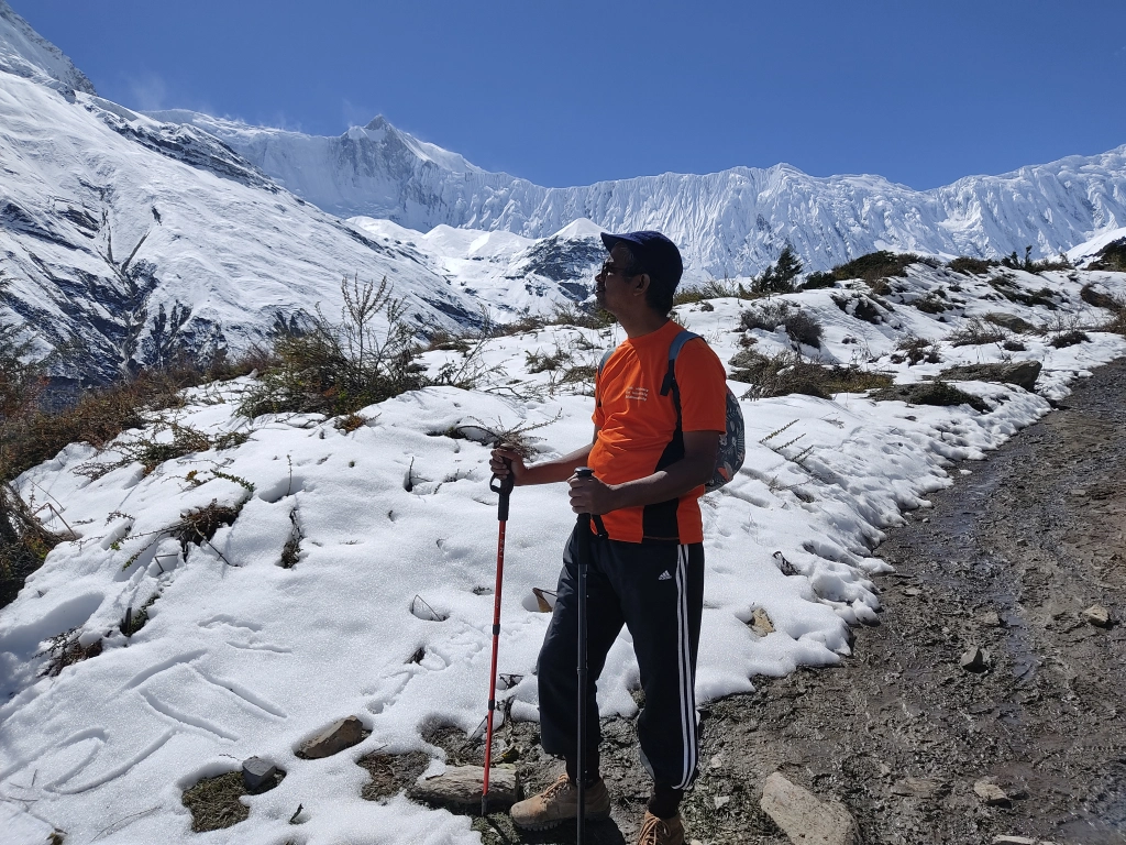
After leaving the hotel, the track reached a junction where it diverged in two directions. One went down towards the valley. That went towards Khangsar, SreeKharka and beyond towards the Tilicho Base Camp. The other route went up towards Yak Kharka, Thorong Phedi and beyond towards the Thorong La. We’d be joining that route after returning from Tilicho lake. In a way, Manang marks an end of the relatively easier section of the trail. From here on, trails would only go up, so will the quantity of snow. As if we were getting closer to the bosom of the Himalayas. The sunshine was warm and the trail meandered through the wide valley. The river cut through it. High mountain peaks rose above its banks.

After the valley, the trail started moving up the slopes. We could still see some vegetation, but they were fast depleting with the advance of the snow line. After reaching the top of the nearest hill, we reached a meadow. Dhananjoy gave some of his acrobatics while we clicked on the pictures. From there, we could see the route on the other side that went towards Thorong La. We could see electric posts on that route, raising our hopes of finding connectivity there. On our side of the route, we could see homes and lodges nestled in the higher slopes. That must be Khangsar (not to be confused with another village on the Leh-Manali highway). A vehicle road also plied along the lower sections of the valley. We moved along and after sometime, found ourselves in the village of Khangsar. Although smaller than Manang, Khangsar was big enough. Routes emanated from it towards Yak Kharka and beyond that, to Thorong La. We walked through the lanes amidst tea houses and crossed a couple of ornate gates with prayer wheels. These are typical of the villages in this area. We left Khangsar behind and plodded ahead. The trail moved up gradually, but walking was still comfortable as it was wide enough. Bushes still lined along the trail. Patches of snow started appearing on the path. These are remnants of the past rough weather that plagued the area for a few days before we arrived. We tried to imagine the plight of the tourists who were trapped in these areas for days with no way to go up (routes to both Thorong La and Tilicho Lake were blocked due to heavy snow fall) or down (trail below Manang was broken at many places due to landslides and heavy downpours, some of which we witnessed while coming up). We were fortunate enough. As the trail went up, the mountains of the Annapurna range came closer and grew in stature. Mt Tilicho, in particular, increased in size in leaps and bounds with every bend of the track.

After sometime, we crossed a monastery and when we looked up, we could see the homes and lodges of Sree Kharka at the top of the hill. We were nearing our destination for lunch. Looking at Sree Kharka, I had a strange feeling. We’d be heading towards it, in the afternoon, the next day, on our way back from Tilicho Base Camp. The lodges looked cosy, especially their dining places.

After crossing a few, we entered the one destined for us and ordered our “Dal bhat” meals. The dining place was marvelous. It had glass windows on all three sides through which we were presented with grandiose views from outside. We could see the glaciers along the slopes of the mountains or their ice falls. They were at that close quarters! While our lunches were getting prepared, we relaxed and enjoyed the majestic views at our disposal. Our guide Brian came up to inform that we’d have to rearrange some of our luggage to leave some of it at this lodge. Since we were supposed to stay at the same place on our way back, there was no point carrying all the luggage over to base camp. That meant some re juggling across our bags and leaving behind stuff that was deemed unnecessary. By the time we finished these adjustments, lunch got served and we jumped over it.

After lunch, we hit the trail once more and started walking leisurely. The track moved out of Sree Kharka. After we moved beyond the tea houses, patches of snow started to appear along the sidelines of the trail. Even at the tea houses, small heaps of snow remained within the alleys between the adjacent rooms. They were remains of the rough weather that plagued the area a few days back. These small heaps still managed to survive the heat of the sun.
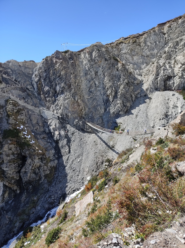
The track moved along level grounds for a few yards before taking a turn downwards after a bend. Here, the trail moved in towards the mountains, forming a ‘U’. There was a steel wire bridge that connected two ends of the trail bridging the gap created by a waterfall that came down the slopes. It was a long, hanging bridge, nothing surprising in Nepal. We’ve seen them in all its parts we’ve visited so far. But the other end of the bridge was supposed to meet at a stair case, which was non-existent. It somehow touched the other end, with the steel ropes clinging on to the bare rocks that were ripped out of the surface by a recent landslide. Footsteps of travelers created a roundabout way of circumventing the staircase below the ropes to join it back on the left side of the bridge with the remaining part of the trail. The “workaround” trail created by local travelers formed the shape of a “heart”. We could see people treading that part very carefully along the slopes of the hill barely able to keep both of their feet side by side. The sight sent some chills down my spine but I went ahead. My boots were skidding while tried to negotiate the “round about” and with the help of the guide, I somehow managed to pull myself up on the other side to rejoin the original trail, which moved up with a series of switchbacks. After reaching safe ground, we all took some time to take stock of the area. Immediately, thoughts poured in me, that we’d have to traverse it once again on our way back (but we were up for a surprise).
After the area, the trail assumed a very different look on the other side. While we had vegetation in the form of bushes lining the trail earlier, now the hills on its sides bore a fully desolate look. Rocks were bare and dry, devoid of any vegetation. Acts of wind blowing through the areas, carved out mesmerizing architectures out of barren landscape. Huge rocks appeared like termite heaps. We came across our first stretch of snow over the trail. I became very skeptical (as I always do) on such trails. I constantly looked for support from my guide, holding his hand, while I treaded the path. At one point, my boot went straight in but fortunately, the snow wasn’t deep and I was able to pull it out. After reaching the other side, I breathed a sigh of relief.

A placard lay by the side with a label stating that the area ahead was a landside zone and we were asked to cross it with caution. We entered a place where rocks on the route almost created a tunnel and the track went through a facade. Railings were present on the left side, apparently to keep travelers from skidding, but the track moved down steeply and the surface was sprinkled with pebbles and gravels. It was very difficult to get purchase on such a surface and I took my steps carefully. Nevertheless, I moved on and after sometime, was greeted with almost a level (though narrow) track along the slopes. When asked about the length of the landslide area, our guide Brian responded “~3 kms”. The good part was that the weather was bright and sunny and we walked comfortably amidst the afternoon sun. But a constant vigil was required as people looked up towards the hills frequently to watch out for falling rocks. I paused at some places to take photos of the amazing landscape that was at the disposal, but time was precious as we had to get out of this area as soon as possible to avoid danger.

After treading along for some more time, we reached another placard that marked the end of the landslide area though the trail beyond it wasn’t much different. Dhananjoy and Niladri walked ahead of me and they stopped suddenly to look up. After a pause, they ran as quickly as possible to move ahead and just as they moved out, a mid sized rock fell on the trail, toppled over and went down to the abys on the other side. It was a stern reminder, what was at stake! Heaps of snow re-appeared and we had to tread through them. Some were knee deep and after sometime, we could see the lodges at Tilicho Base Camp. Normally, this raises energy levels, but a look around the place, somewhat gave me an idea, that this wasn’t a natural place for habitation and we, the humans were forcing our way through it. So sooner or later, nature would have her way of sending us out. It was a strange feeling. We went towards our slated tea house which had heaps of snow lying all over. The cold was biting as the sun moved behind the surrounding mountains but we could see the afternoon glow on the peaks. Mt Tilicho was imposing in its stature and we could see the trail towards the lake along the slopes. It was all white with patches of black. We were certainly looking for hike amidst snow for the morrow.

After dumping our back packs, we headed for the dining space which was packed with travelers from different groups. We met some locals from Nepal who were traveling from Kathmandu valley. They visited the lake that day and were on their way down. They advised us to start very early in the morning (preferably by 4 AM) to avoid the risks of walking on melting snow as much as possible.

Then there was a group from Bangladesh and their advice was the same. Going up was one thing, but coming down the slopes was a very different story with melting snow under your feet. They were made worse by groups that slid their way down along the snowy slopes, making them more skiddy for the walkers. For the first time on the trail, I rued not having brought crampons or microspikes. It was very foolish to heed to the guide, sitting in Delhi, who advised not to carry them. Anyways, I tried to keep my focus out of the discussions to keep my morale up. After dinner, we slid under the blankets, adjusting the alarm clocks an hour earlier for the next morning. We were sleeping at 4919 m.

3 thoughts on “Around Annapurna – Tilicho Base Camp”