

31st March, 2024
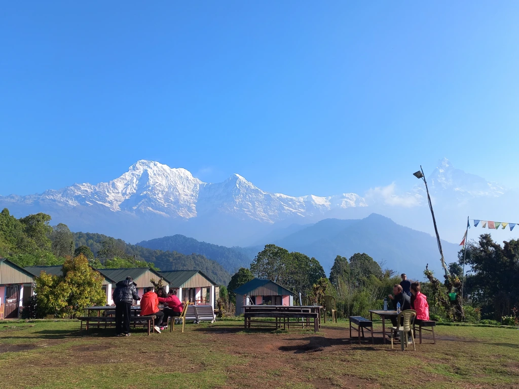
Woken up by the alarm, as I ventured out of our room, the first thing I watched was the state of the sky. Darkness was gradually fading out with a soothing light spreading throughout the skyline. Dark silhouettes of the distant mountains appeared prominently. There wasn’t any trace of clouds near them. I could identify Annapurna South, Hiunchuli and Fishtail on the northern horizon, though all dark at the moment. The cold was intense, though not unbearable. Placing fingers on the camera shutters was proving a bit difficult. The dining place was active with the staffers getting on with preparing the kitchen to serve breakfasts. Sounds of cocks and hens in our lodge (saw a few of them the day before) and nearby localities formed the typical welcome for the upcoming sun, which was now spreading its golden tentacles though the rough edges of the distant hills. The bigwigs of the Annapurna Himalayas still stayed clear of the golden solar rays, but their tops started revealing the snow.

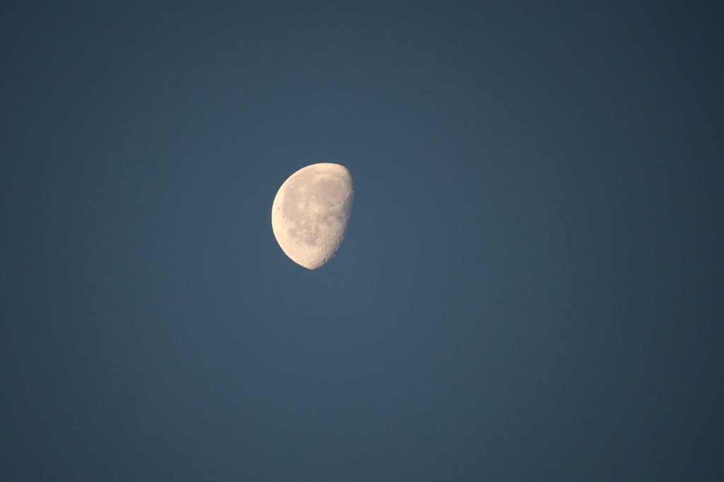
We were all at the lawn with our respective cameras and phones, eager to capture the display of colors on the Himalayan peaks. Our years of experience in such areas have told us to be vigilant as colors change in splits of seconds as the sun makes its journey upwards. On the other side of the theatre, the moon was about to leave, handing over the baton to the upcoming sun.
The peaks of the Annapurna Himalayas became increasingly prominent. From a faint white outline amidst a predominantly dark silhouette, they started to acquire silver crowns, whose dazzling beauty inspired awe from every onlooker in the sprawling lawn. People started asking the guides and porters about their identities. Some even tried to identify Mardi Himal summit amidst the range of snow peaks. While many of them claimed to have found it, I had my doubts.
We had a round of tea while marveling at the morning display of sunshine over the Himalayan peaks. After sometime, breakfast got served. Almost at the same time, we got a disturbing news from one of our members. The sole of Projnesh’s son’s shoes came off and was threatening to separate from the main body. Kunal had a similar experience, but thankfully at Pokhara. So he got a chance to replace it with a new pair there itself. But up here, on the trail, spare shoes weren’t available. I could feel for Projnesh as I’ve faced it before. He did a brave act by tying it with multiple ropes. It wasn’t perfect, but hopefully, should sustain today’s hike. The breakfast was filling and delicious with bread toasts, honey, omelets, tea/coffee and mashed potatoes (a common item in these areas). People stuffed in as much as they could, strapped their backpacks and hit the trail.
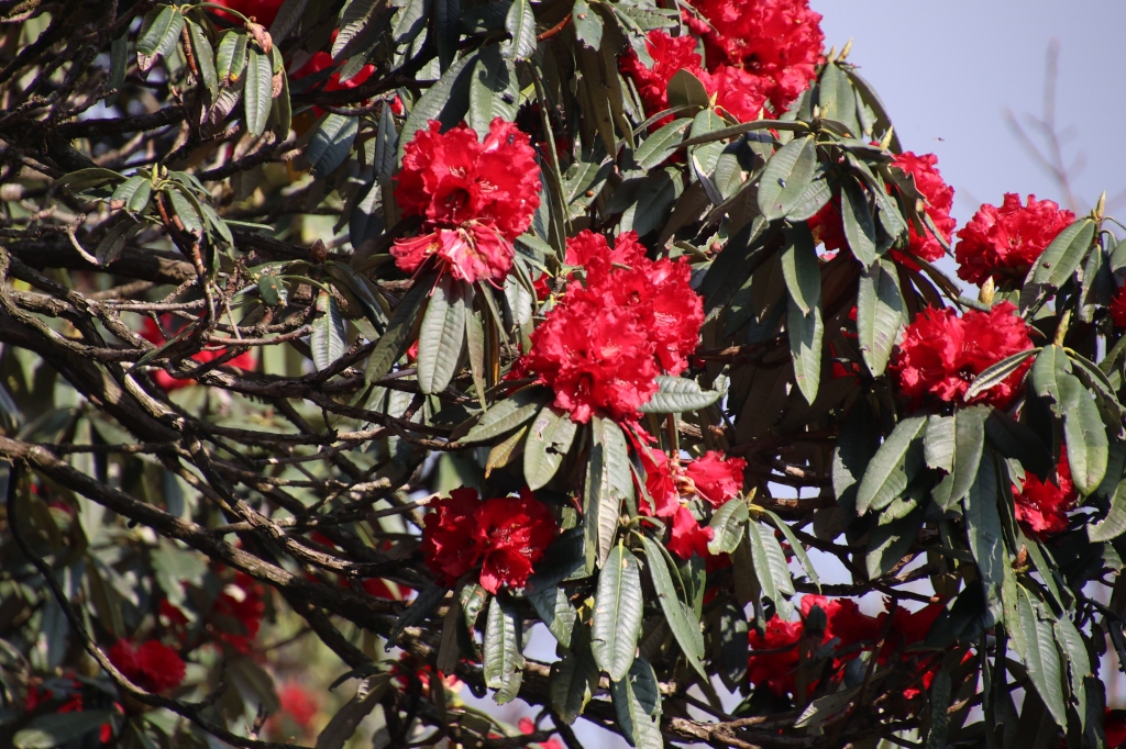
Today’s hike would take us to Rest camp, a destination which is half an hour beyond the Forest camp (which is a more common halt on the way up). We found the idea to be good as it’d advance us a bit more for the next day’s hike towards the High camp. The trail was similar as the day before, to start with. It wound up the slopes amidst dense rhododendron forests, the density of these trees increasing by the height.

However, as we moved up, phases of tracts with stairs increased. This was going to be the first day with full trekking and going by the estimates, it was supposed to be a normal day (not as easy as the day before) as far as hiking goes. It should take us to at least 2520 m (the Forest camp), but more than that. After exiting Australian camp, we continued gradually upwards till a village called Pothana. This place is a junction and one could change tracks to switch to the Annapurna base camp (ABC) route which ran in parallel to this trail. Rather most of the trekkers use this junction to hatch on to the Mardi Himal route from the ABC route. We passed through many local villages and lodges that dotted the trail amidst dense forests. The group, though started together initially, split into smaller sub groups, each walking with their own speed. I found myself alone after sometime (which I always do), inhaling the freshness of the forest dew and air. After passing through the premises of Pothana, we came across a point from where a trail moved steeply upwards. An arrow at that junction pointed to Pitam Deurali and Samjay Deurali – two villages that awaited us in the higher slopes. Nepal has many villages with same or similar names across different trails (at times, also on the same trail). Deurali is one of such names. There’s a Deurali on the ABC trail (just before Machhapuchare Base Camp) and here, there seem to be two more. Other such repeated names are Jagat and Tatopani. The latter indicating the presence of a hot spring nearby. The Annapurna Himalayas played hide and seek with the forest canopy, revealing or hiding themselves depending on the tree cover.

Other members of the group waited at the junction for the rear to come up, going by the instructions of Shishir, the guide who was with the group at front. Some of the members were carrying their own luggage (and were not using the services of porters). Dhananjoy was one of them. It’s obvious, they’d need to give their backs some much needed rest at regular intervals. As they waited for the rear group to catch up and gulped down water, I kept moving up the slopes towards the “elusive” Samjay Deurali. After plodding up for sometime, I came across a few tea houses with a board displaying the name “Pitam Deurali”. I seemed to have crossed the first part, the next awaited village should logically be “Samjay Deurali”. Rhododendrons kept company as I moved up towards that “elusive” village.

After leaving the tea houses of Pitam Deurali, I hiked for quite a long time to reach a second set of tea houses and another board displaying the name of the place. On reaching near it, to my dismay, I found it to be again as “Pitam Deurali”. How can it be? Places aren’t that far apart in these areas and I’ve walked for at least 20 minutes since my initial encounter with “Pitam Deurali”. Nevertheless, it is what it is. There was a shade and I entered under its shade for some rest. As I waited there, other members caught up and joined me. Some took the opportunities to freshen up themselves by visiting the washrooms of the nearby tea houses. On asking Shishir, I came to know that our destination for lunch was “Lovely viewpoint” – somewhat unique name, one has to say, though what’s unique about it, is something we can only decipher once we reach there.

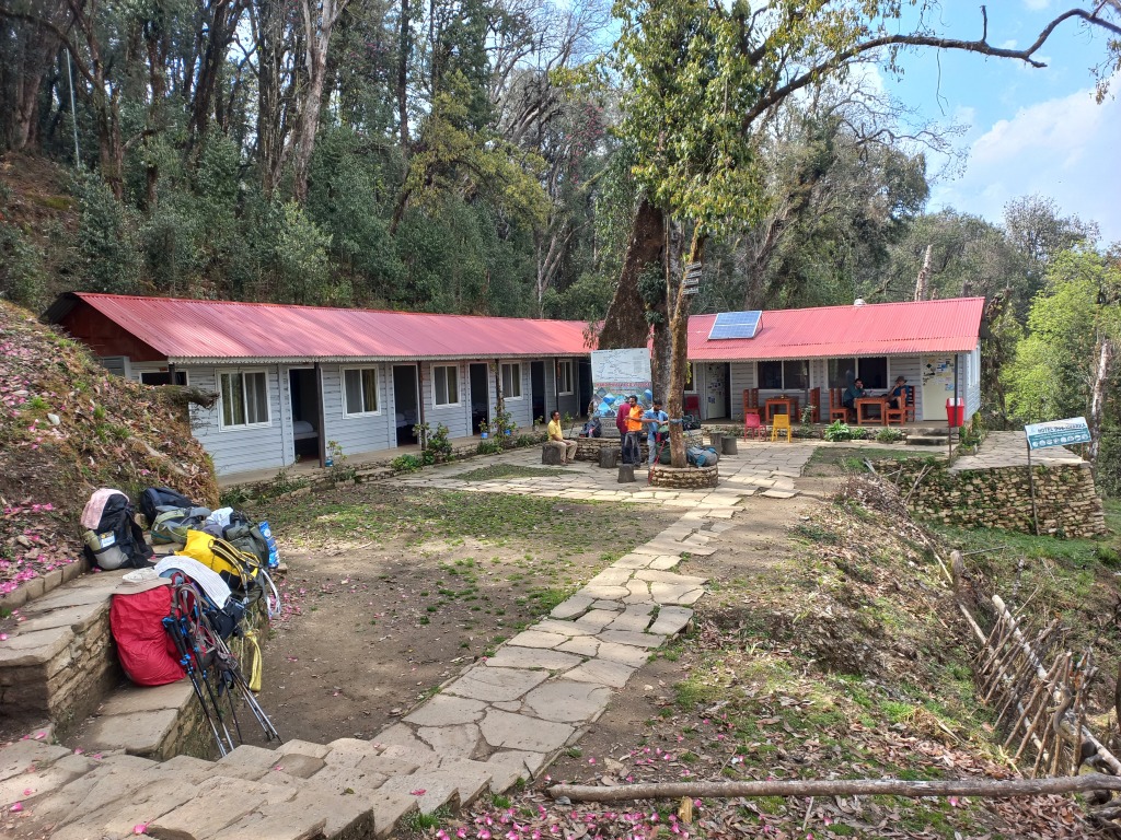
After some rest, we resumed our hike. The trail once again moved inside the forest, but the hike was gradual and comfortable. The presence of canopy also helped with ample oxygen. The same hike through an exposed ridge would have been more tiring. The sequence continued with more patches of tea houses interspersed with canopy walks till I reached a village which finally displayed the label of “Samjay Deurali”. It was a milestone of sorts, given the numerous “Pitams” that I came through. The stairs started reappearing, giving an indication that we were gaining height quickly. The trail also started to have switchbacks. After traversing a few of them, I was able to see a few tin shades of some tea houses placed on the slopes high above. That must be the “lovely view” point. A slow hike, ultimately led me to that point and I made myself comfortable in its dining place. The small lawn bathed in sunshine, but the atmosphere was cool, thanks to the forests around the place. It was 11.30 AM. To save sometime and with the hope of leaving the place after an hour, I asked Shishir to order lunch for the entire group. I asked him to confer with Kumar for the preferences of the rear group over the walkie talkie. All of that initiative was to save time. However, it turned out that the tea house staff was busy preparing lunch for another group and only after that, they’d resume taking further orders. A quick view around the place, revealed Mt Dhaulagiri, while other members of the Himalayas were behind clouds. This was the first point (and may be the only one) which provided a view of Mt Dhaulagiri (which may be one of the factors for it’s name “Lovely”). Our guide Kumar showed us villages along the slopes of distant hills. He pointed out Chomrong as one of them. It’s an important junction on the ABC trail. We could also see the motorable roads leading down the slopes towards Pokhara. They are the ones which we’d ply on during our return. With the help of Wi-Fi, we called to our homes.
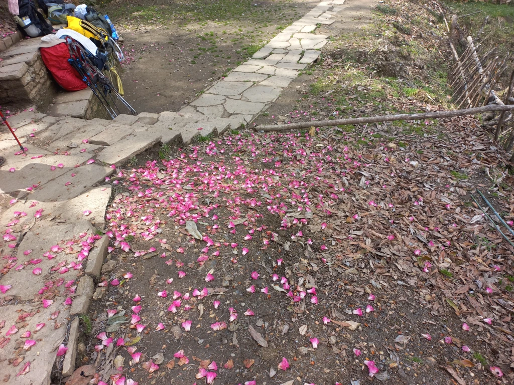
It took us almost two hours to resume the hike after lunch, most of the time going towards waiting for our lunch to arrive. Nevertheless, the lunch was fresh and filling and after it, I resumed the hike along the other slope of the ridge which we hiked to reach “Lovely view”. This time, I had the company of Niladri, Sagor and Mishti. The trail went deep inside the forest and walking was comfortable under the shade. Much to our pleasant surprise, we suddenly noticed that the shades of rhododendrons have changed. From dark red in the lower reaches, it now acquired a blend of light pink and white. May be altitudes have a factor to play in the shades of color.

The trail moved along taking us up the stairs, only to bring us down after sometime, but we enjoyed the canopy cover & the rhododendron blooms. The density of the forest increased (which was expected, as we were approaching the Forest camp). With that, the trail too diversified into multiple branches going through the gaps of the firmly rooted trunks. For a moment, it confused us, but Niladri was quick to spot a blue and white paint (which he termed “Messi” due to its resemblance to the Argentinian flag) on the trunks of the trees showing the way through the maze. After spotting that mark (which was consistent till up to Badaldanda), it was easy to spot the route. We kept talking with each other and kept plodding ahead.
On our way, we reached a junction, from where the straight route led to many tea houses at a distance, the Forest camp. The other route winded down the other side of the slope in a series of switchbacks, with each dropping down more steeply than the one above. That route led to Landruk. We’d have to take that trail on our way down from Mardi Himal. Forest camp is probably the first big halt on the way to Mardi Himal. It has many tea houses and we found it to be a bustling place. Actually, not many people halt at Australian camp as it’s not really a part of this hike.
The forests around the “Forest camp” were full of rhododendrons with many shades. This was unique. So far, we’ve been seeing a single variety in an area, but may be Forest camp was a blending point where one variety gives way to another.

From the premises of Forest camp, a set of stairs went up the slopes and we started climbing them. Our legs were tiring and it showed at the speed with which we moved up. Every set of ten steps (which was down to two/three for some other members) forced us to stop and breathe before taking on the next. But we knew, every ground gained today will be an advantage for the next day, which was supposed to be a steeper hike. The long winding and seemingly never-ending stair cases finally came to an end at the lawn of the Rest camp. By that time, the clouds held the sway over the mountains. After settling in our respective rooms, we relaxed at the lawn as remaining members of the group were yet to arrive. They finally showed up in groups of one or two as we sipped hot tea. Discussing the proceedings of the day with tiring legs, sipping smoking tea, took away most of the fatigue. We looked at the hike for the next day, but that was still an evening away. An evening, that we’d be spending in the dining hall, with snacks, tea & cards. We were to sleep at more than 2520 m.

2 thoughts on “Mardi Himal – Rest camp”