Where the sun rises first in India – part 2

Part 1

Tawang is inhabited by the Monpa tribe of Arunachal Pradesh. The monastery at Tawang has importance in the context of Tibetan Buddhism. The region has both spiritual as well as political significance. Tawang is the place where the 6th Dalai lama was born. It is also where the 14th Dalai Lama stayed for a while as a part of his escape from Tibet in 1959.

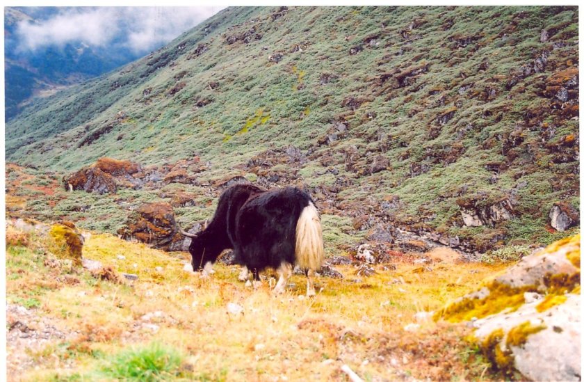
As I stood on the edge of a hill overlooking the valley on a clear morning, the entire town appeared before my eyes along the slopes. The Tawang monastery was at the right end of the 180 degree view that was at my disposal. Our schedule for today was to visit Bum la, a pass at 4600m (15,200 feet) above the sea level on the Sino-Indian border. It is only about 37 km from Tawang, but the gain in altitude was significant. One requires a special permit to visit the Bum la pass and we made sure to acquire one in addition to the general permit to visit Arunachal Pradesh. We started off for Bum la after breakfast. As soon as we left Tawang, the road started winding up the slopes and vegetation started to thin out. We had to present out permit documents at multiple army posts on our route. Gradually, we had to let go of the luxury of traveling on a formal road as now our vehicle was simply jumping across the boulders on the uneven terrain. Maintaining an upright posture was proving to be increasingly difficult as our heads frequently collided with the roof of the vehicle. However, all that were merely operational aspects as the terrain was changing drastically as we moved up the slopes. Bushes and shrubs waded out and it was all rocks and boulders. Patches of snow started to appear on the higher mountains and such patches came closer to the ground as we gained altitude.

yak
En route Bum la

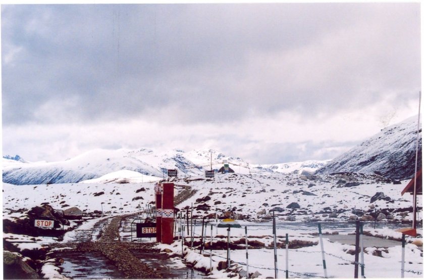
The patches of snow that initially interspersed the black and brown terrain of boulders, now converted to entire swathes of snow covering the entire slopes on all sides. We were reaching near to Bum la. The vehicle continued to move up and after the final ascend of a slope, we entered a flat plateau with a vast stretch in front of us. the road suddenly became level and we could see the border posts. Finding a level stretch after a bumpy ride made our driver ecstatic and he pressed the accelerator pedal and the vehicle whistled along the road that slit through the snow-covered mountains on all sides. That’s when we heard shouts from behind asking us to stop. Only then we realised that we were almost about to enter the Chinese territory and had to pull back. At the far end of the slope, we could see the fences and posts on the Chinese side of the border.

bumla
Bum la

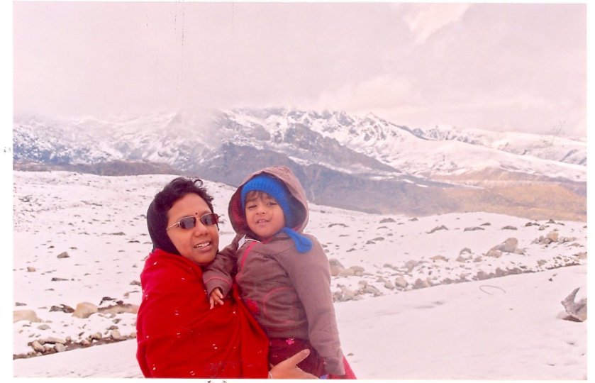
Strong winds greeted us as we ventured out of our vehicle and crystals of snow lashed at our faces. The road continued to the other side of the international border into what official is “foreign territory”. That’s when one realises how futile are the political boundaries, which are nothing but divisions created by humans.

border
International border at Bum la

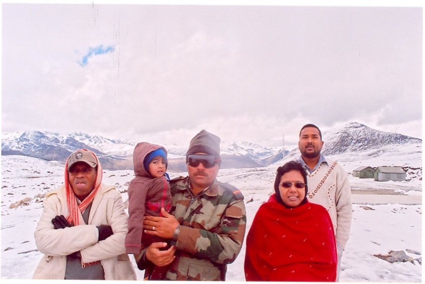
Neither the mountains nor the flora and fauna care about it. Nature doesn’t discriminate, but humans do. The attack on the Indian territory in 1962 started from the north of Bum la. What appears as a vast and silent stretch, became a boiling pot on one fine morning. As we saw around us, we could see army posts on top of every surrounding peak on both sides of the border. The army personnel who were posted there, shared their experiences at the border. In such sub-zero temperatures, they continue patrolling the border 24 hours a day, 365 days in a year. The soldier who chatted with us had his home in the distant state of Haryana in north-western India. He was on his 2nd year of posting at Bum la.

army
Soldier at Bum la

After sometime we were advised to leave the place, primarily because of the cold and cloudy weather and because my daughter was only a little more than a year old. We went back to our vehicle and headed down the bumpy slopes on the way to reach Tawang. After a lunch with momo, our next destination was Tawang war memorial. The war memorial was erected as a mark of respect to the Indian soldiers who laid down their lives in the Sino-Indian conflict of 1962. Many remains of the materials and arms used in the conflict are preserved in different enclosures with descriptions explaining the context of their usage. As we moved around the different sections of the memorial, we found innumerable names inscribed on the murals.

warmemorial
War memorial – Tawang

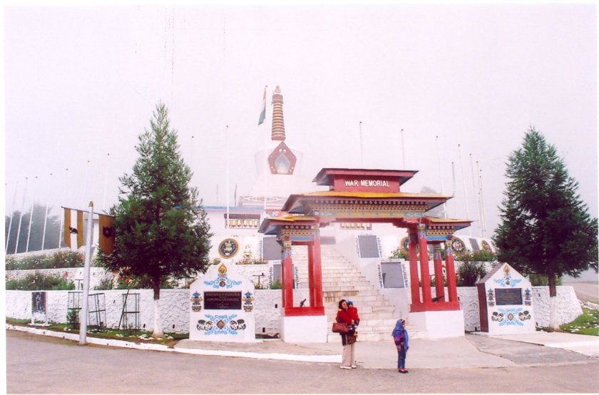
Models are kept at the memorial that depicted the troop movements during the days of the war annotated by dates of the key events.

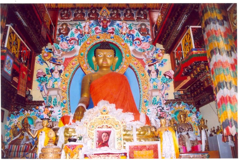
The next day, we visited the Tawang monastery. It was situated at one end of the Tawang town. We visited the main place of worship that had a large statue of Gautam Budhha and a big portrait of the 14th Dalai Lama. Then there were the hostels where religious students stayed. There was a museum with antiques from the days when the monastery was first established.

monastery
Tawang monastery

Our final day at Tawang ended with a dinner at a local restaurant with a menu of squash curry and momo.

Our return journey the next day, we spent some time once again at the Nuranang falls, purchased some vegetables at the local market at Dirang, enjoyed the views of Se la pass and finally ended our journey at Bomdila. On our way down, we were obliged with views of distant Himalayan peaks lying in Tibet in a clear sky.

peaks
En route Dirang from Tawang

The next day, we started off from Bomdila and the road descended through the familiar terrains. We spent some time besides the Kameng river at the beautiful Tenga valley.

tenga
Tenga valley

Our second stay was at the border town of Bhalukpong. Just before Bhalukpong, we entered the area of the Pakke tiger reserve. Pakke was actually an extension of the Nameri forests of Assam into Arunachal Pradesh. When we reached Bhalukpong, the sun was already preparing to bid adieu. Bhalukpong is a place surrounded by forests. The hotel offered magnificent views from its balcony of the Kameng river as it descended the mountains to enter the plains of Assam where it is called by the name of Jiavarli.

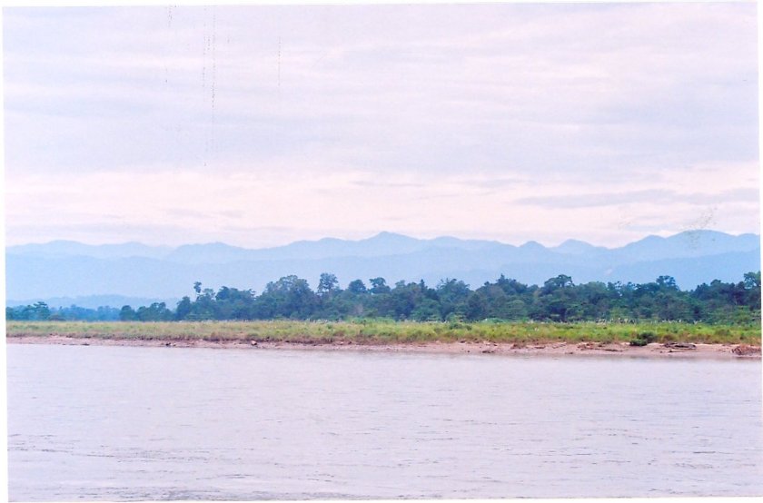
The next day, on our way back to Guwahati, we paid a visit to Nameri with the hopes of a jungle safari, but were disappointed to find that safaris were not yet allowed at Nameri because the monsoons were yet to subside from the region. We went on a small trail till the banks of Jiavarli river. The river flowed through the plains of Assam with dense forests on the opposite banks of it which climbed up the distant mountains of Arunachal and merged into the forests of Pakke tiger reserve.

nameri
Nameri

We all felt that at sometime in future, we will make a trip to Nameri along with Bhalukpong. Hopefully that time will come soon but till then, with a heavy heart, we bid good-bye to Nameri and the distant hills of Arunachal as we headed towards Guwahati.

Part 1

Where the sun rises first in India – part 1

Part 2

“North-East” – the word itself has a connotation of unknown and unexplored in the context of India. You have the Himalayas, low-lying hills, forests of the Terai (the foothills of the Himalayas) and there is Brahmaputra and its tributaries. None of these sound new. What you get there, you get elsewhere too, at least in geographical terms. Yet it is very different from the rest of India. That’s simply because, not many parts of it has been ventured into. The hill stations, villages, flora and fauna are unique and still pristine. International conflicts and local disturbances have kept it out of reach from rest of the country for long. Connectivity is yet to reach in its remote corners. The lack of exploration has created an aura of mysticism around the region. Out of the different states out there, the biggest in terms of area is Arunachal Pradesh and probably the most unexplored as well. Previously known as North-East Frontier Agency, majority of the state’s terrain is mountainous and is covered by forests. Till today, Botanists and Zoologists continue to find new species of flora and fauna in the forests of Arunachal. It is the home to the Eastern ranges of the Himalayas. Arunachal is also the state which welcomes the river Brahmaputra (Siang, as it is called in Arunachal) as it enters the Indian territory from Tibet, where it travels for a long distance as the Tsang Po river after its origin at Manas Sarovar lake in the western Himalayas. It is probably the only river that traverses the length of the Himalayas.

All such stories have haunted me for long and I’ve always strived to visit the region. Finally, the time came in the year 2010. Plans started in August and we found ourselves heading to Kolkata on a morning flight in the month of October. After reaching home, we got ourselves fresh and spent the rest of the day visiting some of our friends and relatives. My sister-in-law arrived the next day with her family to join us. Arrangements were complete for a cab to pick us up at 6 AM, the next morning for a drop to the airport. We went to sleep after setting an alarm in my cellphone to wake us up at 5 AM the next day. However, the next morning I woke up by the sound of missed calls from the cab driver. It was already 6 AM. But how come the alarm didn’t set off? A quick look at the cell exposed the reason. While I set the time of alarm meticulously, I forgot to turn the alarm on! I rushed others to wake up and get ready quickly. Fortunately, we could board the flight on time from the Netaji Subhas International Airport as traffic woes were absent in the morning. Our flight was to Tejpur via Silchar, a city in the Barak valleys of southern Assam. It took us about 2 hours to reach Tejpur. The airport was very small and ours’ was the first flight to land at the airport that day. By the time we got ourselves fresh at the airport toilets and exited, the same flight was ready to take off for its return journey. Ranjan da (my brother-in-law) already made arrangements for a vehicle which was standing in the parking area. This vehicle was to accompany us for the entire tour in Arunachal and would finally drop us at Guwahati.

Tejpur is the gateway to western Arunachal. It is a city on the Northern banks of the river Brahmaputra. The name Tejpur derives from Tej (meaning blood in Sanskrit and Assamese languages) and pura (meaning town/city in Sanskrit). Legend has that in the battle between Krishna and Shiva, Banasura’s (a disciple of Krishna) army fought for the rescue of Aniruddha (Krishna’s grandson). It is said that there was so much blood shed in this battle, the entire place turned red. That’s where the place derives its name from.

After settling our luggage on the roof of the car, we started off with our journey. Our destination for the day was Bomdila, which was about 156 km. We whizzed through the streets of Tejpur amidst the greenery of the fields. The weather was cloudy and the air was fresh. Gradually, fields gave way to trees and their density increased. We were now going through the forests of Assam. The smell of freshness from the forests and the chill in the air was refreshing. We were going through the forests of Nameri National Park. The serpentine black road went right through the middle of the forest with trees closing in from both sides to form a canopy. I noticed after every km on the road, there was a soldier posted beside. We were stopped a few times where the soldiers asked about our whereabouts and destination, checked our identity documents. All these security checks reminded us that we were in a region close to the international Sino-Indian border. In one such checkpoint, a soldier complained to Ranjan da about the poor connectivity of the state-owned telecom provider (by now he was aware that Ranjan da worked for BSNL, the state-owned provider by his interrogations). He was visibly upset that soldiers like him had to work in these remote areas away from their families and they couldn’t even connect to them thanks to the lackadaisical service of the state-owned telecom provider. We reached Bhalukpong, the border between Assam and Arunachal Pradesh by noon. There was a gate where we had to stop for security check where officers checked for the permit to enter Arunachal Pradesh (Ranjan da had asked a local officer at BSNL, to arrange for the permits). People visiting Arunachal (including Indian citizens) require an inner line permit (with proof of their identities and details of their itineraries) and only in the event of successfully obtaining the permits, they are allowed to visit. We had to wait for sometime at the local BSNL office for our permits to arrive.

After Bhalukpong, the road started moving up and went by the banks of the river Kameng. Mountains on both sides were covered with dense forests and it was green everywhere. For the first time in my life, I saw banana trees on a mountainous trail. Our driver told us that these bananas were of a wild variety and not edible. It was drizzling and the weather was cloudy. The road was very bumpy and was muddy at many places as work was going on for its widening. Very often we had to make way for convoys of trucks of the Indian Army carrying goods to distant areas of Arunachal and to the army posts at the international border.

forests
River Kameng

Every inch of the mountain slopes was covered with green. It was just after the monsoons and this is a region that receives heavy rainfall, which was apparent from the greenery. Waterfalls flowed down the slopes every now and then. I’ve traveled on mountainous roads on many occasions, but most of them have been in the western Himalayas. But what my eyes were presented with now on this trail, was something I’ve never witnessed before. The vegetation was very different and was more dense than any other parts of the Himalayas. As I’ve already said before, the forests were abundant with banana (something which is normally seen in the plains) and bamboo trees. Air got more cold as we ascended higher. Suddenly, my daughter (who was a little more than a year old) started feeling uneasy and started vomiting. We had to stop by the road to give her some rest and apply water to her face for comfort. Though she was administered some mild medicines to avoid nausea before we started our journey at Tejpur, it turned out that the mountainous terrain started taking its toll on her. I got a tad nervous as she was doing fine till now, but we still had a long way to go before the day’s halt at Bomdila. Some of our relatives advised against taking my daughter to this tour as she was still very young to undertake such a journey. However, after some rest, she felt good and we moved on only to stop at regular intervals for the same problem. This ate into our time big way. The forced stop at Bhalukpong for the permit and now these breaks only added to our already delayed run of the day and Bomdila was still far. We were also forced to move at a slower pace than normally what is possible on a mountainous road because of the surface conditions, the ongoing road extension work at multiple patches and lost time to make passage for ongoing army convoys.

falls
En route Bomdila

But all these tensions were overwhelmingly beaten by the views of nature we were offered with. There were no reasons to complain whatsoever and all such problems are part of the game in the mountains. We were going through the West Kameng district of Arunachal. The vegetation now changed and we were seeing less and less of banana trees. It started getting dark as sun sets much earlier in these eastern parts of India and by the time we reached our rest house at Bomdila, it was already dark. We stayed at the rest house associated with the Bomdila monastery (an important one on this trail). We were offered with delicious and hot mixed vegetable curry and chapatis for dinner. It was here, I first tasted the delicious vegetable squash, which was to become a regular part of our staple diet from thereon in this tour. As we were tired by the entire day’s travel, it took no time for us to go to sleep.

monastery
Bomdila monastery

The next morning, we got ourselves prepared and hit the road early. We had to reach Tawang by the evening, which was 172 km from Bomdila. Our route for the day was going to be very interesting as we were to cross the famous Se la pass on our way to Tawang. The road after Bomdila started to ascend further and the vegetation started changing. The density of the forests decreased as trees became sparse. Gradually they gave way to shrubs and bushes that were of yellow or red colors. Clouds came closer to us as we gained heights and finally we were at the Se la pass. A gate welcomed us at the pass and right after crossing the gate we were awestruck with the view of the large expanse of the Se la lake with distant mountains on its banks.

sela
Se la pass

As soon as we came out of our vehicle, we were greeted with extreme cold winds lashing at our face. We had to be careful with our daughter. We spent time enjoying the beauty of the lake and the pass. Se la pass is at a height of 4170 m (13,700 feet), the highest point in this route. The road from here was downhill and after sometime we reached Jaswantgarh. Jaswantgarh is an important place on this route. It was here where the brave Indian soldier Jaswant Singh Rawat of 4th Garhwal rifles fought bravely and laid down his life defending his post. In the process, severe fighting ensued and Jaswant and his comrades caused heavy casualties to the aggressor Chinese army before laying down their lives. There is a war memorial erected in his memory. Every tourists who pass by this place, are offered with free snacks and tea at the nearby army canteen run by the soldiers and we were no exception. The hot tea and snacks tasted wonderful in this biting cold and it was more warm because of the hospitality offered by the soldiers. It’s for them, that we sleep with peace and they are the ones who made it possible to visit this remote Himalayan region. After Jaswantgarh, we moved on and crossed Dirang. After Dirang, our driver halted the vehicle at a place. We came out and walked down a narrow trail from the main road to reach a place and were awestruck by the sight of a massive waterfall amidst the forests. Huge volumes of water thundered down the slopes above. The waterfall appeared like a stream of milk flowing through the surrounding green forests. The splashing water droplets formed a rainbow amidst the fading sunlight of the day.

jangfalls
Nuranang falls
jangfalls2
Nuranag falls

We spent a lot of time at the falls and no one was ready to leave the site, but time was running out and our driver hurried us. We hit the roads again and now we were into the last leg of the day’s journey to Tawang. Just as the day before, the sun slid down the horizon almost suddenly and it was pitch dark. Tawang was still some distance away and the jeep meandered through the serpentine mountain roads with its headlights as the only source of light in the darkness. After reaching Tawang town, we came to know that the NTPC guest house (arranged by Ranjan da) was not available for us as some executives were staying there. We couldn’t complain as this was the norm (the rest house was meant for stay of NTPC staff). So, we moved over to the BSNL inspection quarter (also arranged by Ranjan da). The rooms were big and we slid into the blankets after having dinner. Sleep embraced us with open arms after the day’s tiring but rewarding journey.

Part 2