In the land of the Sherpas – the preparation

Kathmandu

As I said in my previous post, interest was building up for a few years. But it took a big blow with the devastating earthquake hitting Nepal in the early summers of 2015. The horrific pictures of suffering that emerged from Nepal made the thought of going there impossible for at least another 4-5 years, or so it appeared at that time. During the first three months of 2015, I got in touch with Mr Tej Bahadur Gurung, the proprietor of Nepal Alternative Treks and Expeditions and he landed up as my Facebook friend. His regular updates from Nepal, especially about the recent developments kept me aware through the days of trauma that Nepal went through. Gradually, despair gave way to hope. Successive photographs from Tej about the different expeditions raised hopes. It came across, that the Everest region & the route somehow survived nature’s wrath. The damage to the trail has been recovered or at least was on the way of it.

Life presents you with questions at every corner. Solving one unearths others. Now that Nepal (or at least Everest base camp) was deemed reachable, the question of getting leaves from work came up. It wasn’t insignificant. From what Mr Gurung, my friends who’ve visited the region & finally, the internet, had to say, it takes about 13-14 days from Kathmandu to Kathmandu. Add to that, the travel to and from Delhi. All said, we were looking at about 15-16 days. That seems manageable. But, hold on, there’s the Lukla flight. That, in itself, is a “big variable” in this equation. Probably the one with most uncertainty. A quick hunt for information told me that flights to this distant air strip are very uncertain and weather always holds the trump card. Flights on this route are not controlled by sophisticated ATS systems, but by clear visibility. Simply put, if the pilot can see the air strip, the flight will land and similarly, while taking off, the hills in front has to be visible. Delays because of cancellations are not uncommon and all of whom we spoke to, advised us to have at least 2 days in buffer to account for them. Little did we know at that time, that even two days might prove insufficient and we’d have to think of alternatives. But that’s a tale to be told later. All said, we were looking at 17-18 days off work. Hmm, let’s see how it shapes up. But even before all that, my mind was caught up in another challenge. “Can I do it?” One section of it kept pushing me. “There won’t be another chance in life. Age is not going to be in your favor for long. So have it while it’s hot.” On the other hand, the son, the husband and the father in me kept dragging me. “Don’t be crazy. It’s not Kedarnath where you’re not forced to walk, mules can do the job for you. It’s not a 2-3-day affair. It’s a good fortnight of walking for at least 7/8 hours a day, getting to altitudes as high as 5500 m. You’re jumping into English Channel right after a swimming pool.” Asking different people for opinions gave mixed results. There are some people whom I preferred not to ask as the answer was always going to be negative (that includes my family members). Responses from others were subject to interpretation. It all summed up to “Look, you’ll have to walk hard, it will be tiring, you could run out of breath or do fine at the altitudes, depending on how fit you are or can become during the days of the buildup.” But all of them agreed that the trail, though tiring, is not dangerous and people of differing ages and varying trekking experiences have done it before. As it always happens, I finally reached a point when I thought, enough questions have been asked, now it’s time to move forward. After making up my mind, I gave a call to my bosom buddy and all-weather friend and travel partner Niladri (Niladri Sekhar Guha). He sprang up (as he always does) at the idea. After hanging up the phone, I wondered why bother asking others when a single phone call could solve it in a few minutes? Over the years, we’ve been travelling together (with our respective families) along with other friends. If Niladri turns down an offer to travel, it has to be a natural calamity. Getting leaves from a private IT firm for close to 3 weeks (well, at least 17 days) isn’t easy even by most lenient standards. But wait, didn’t I complete 5 years at my organization (or rather, will complete it before the trek commences)? What it meant that I’d be getting an extra 10 days of leave once I complete 5 years at my company. Great! This has to be it. As they say, when the Himalayas call, none can resist it. At least I can’t let this opportunity fade away.

IMG_3871
One of the many wire bridges to cross on the trail

With leaves now sorted, it was time for planning. That wasn’t a small affair either. We first needed to form a group. Just two of us won’t work as the tax bracket we belong to, won’t allow that luxury. I reached out to my brother-in-law, Ranjan Ghosh, an employee at the Central Government of India. His love for The Himalayas had suddenly taken off with his interest in photography (primarily for birds). “Everest base camp? Hmm, that might be a big ask at my age, let me think over”. I tried my best to wipe out his last of doubts by citing numerous narratives I heard from others (carefully weeding out the negatives). With him still doubtful, I didn’t press on further, thinking he might be better off being left on his own to make a decision. If he comes back with an affirmative answer after giving a good deep thought, it’s better for the group as we’d have a committed member and that’s very important in a trek like this. Niladri, in the meantime managed to rope in one of his office colleagues, Siddhartha Bhattacharjee. With head hunting still on, I continued my inquiries about the travel. I resumed my interactions with Tej Gurung. The itinerary that he provided (which is standard) ran like this:

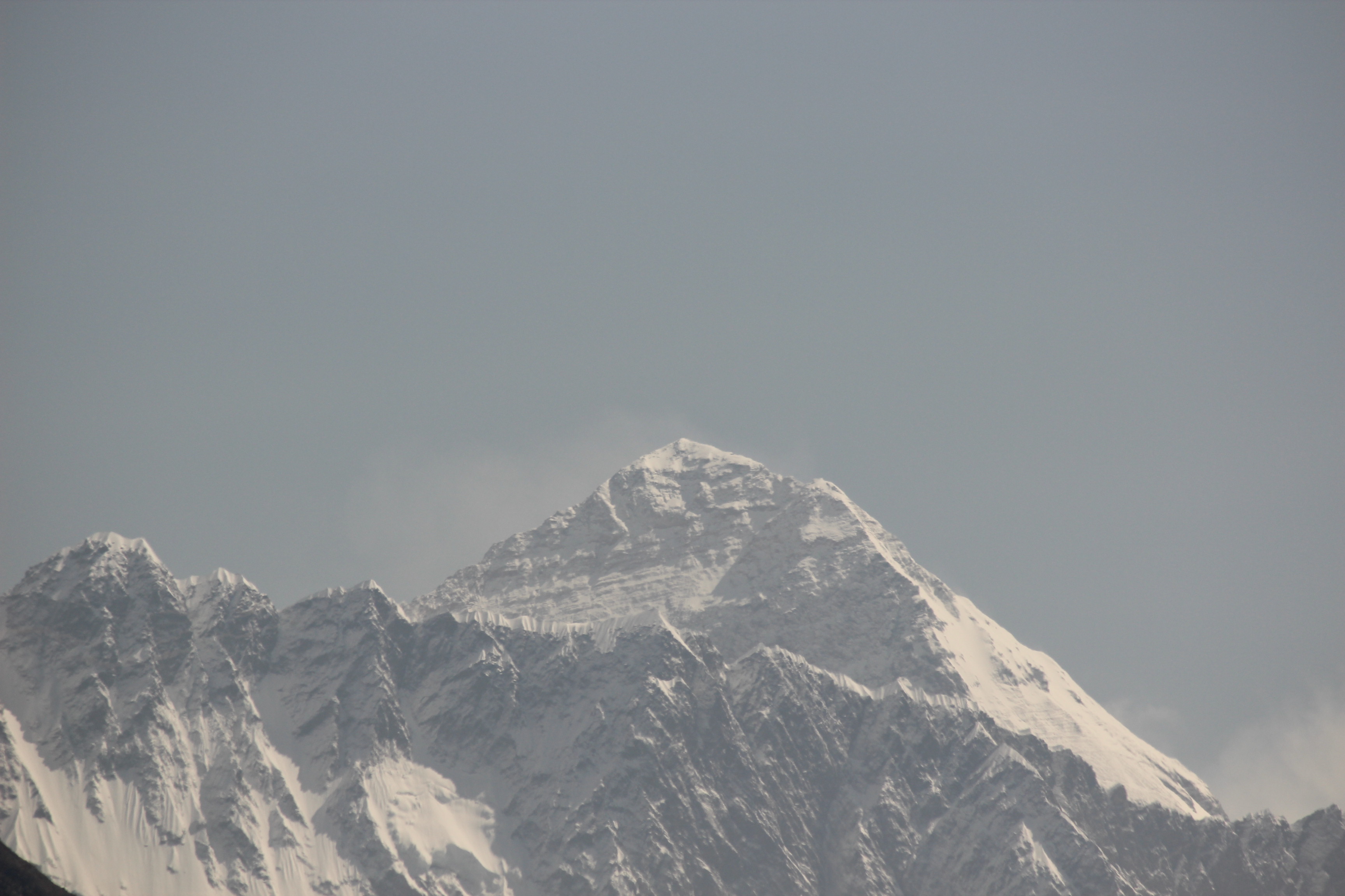
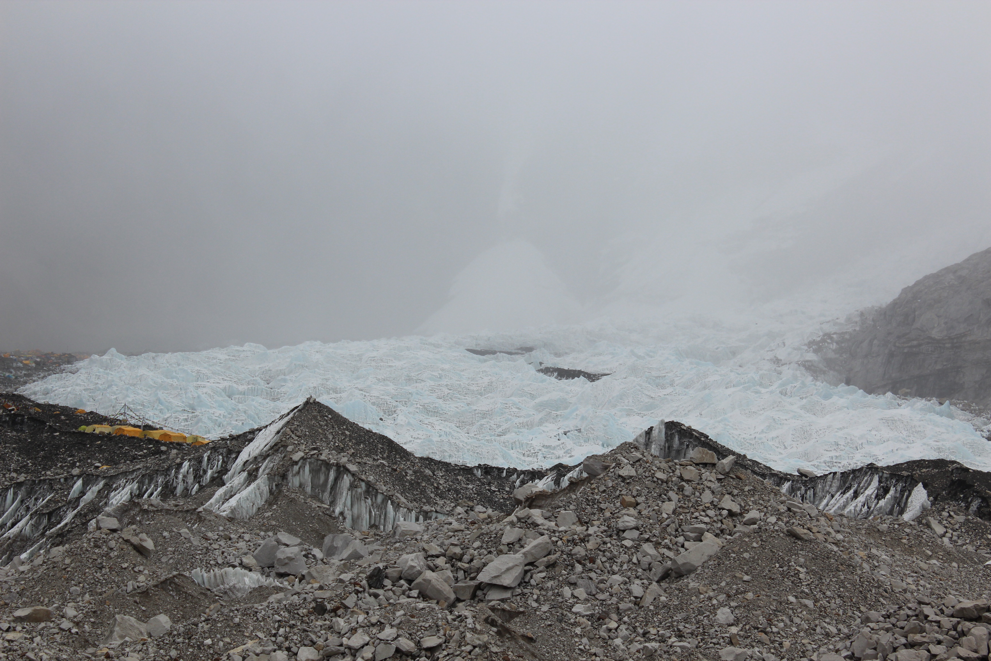
It would start from Kathmandu with a flight to Lukla, followed by a few hours of walk to Phakding, the place of our first halt. Next day, the maximum gain of altitude in a day (about 800 m) would take us to Namche Bazaar, the Sherpa hub of business and culture, the largest town of the Khumbu region. The following day was supposed to be a rest day, to acclimatize our bodies to higher altitudes. Rest, by the way, would not mean just relaxing. It would rather mean hikes to nearby places for about 2-3 hours and back. In this case, a hike would take us to the “Everest view hotel” from where we were expected to get the first glimpse of Mt Everest along with its neighbors. After that, successive days would see us gain heights gradually and reach the places of Tengboche (which has the largest monastery of the region), Dingboche, Lobuche and Gorakshep respectively. There were no extra rest days in the entire route apart from one each at Namche and Dingboche. We were to reach Gorakshep from Lobuche, have lunch there and tread on further to Everest base camp, the same day and come back to Gorakshep to stay there. The following morning would see us scale the heights of Kalapathhar to have the full view of the peaks and glaciers of the Everest region. The way back was similar, except that it did not involve staying at every place, given that we would be on our way down. Tej Gurung’s itinerary wasn’t just a routine. It had enough meat to get one charged up with romantic and adventurous description of the trail. According to that, Kalapathhar was supposed to be the climax of the entire trip. Apparently, when the sun would rise from behind of Mt Everest (to be able to see that, one would have to start ascending from Gorakshep at dark hours of the night), the edges of Pumori, Ama Dablam and many other stalwarts of the Everest region would start bathing in gold till that transforms to dazzling silver. It was supposed to be a treat to our eyes for the entire 360 degrees around us. Well, well! It was difficult to hold our breath. But, there’s not much time for romanticism as it was already January 2016 and we were to move fast as the window of our visit zeroed in on first half of May, as that would provide us the best weather before monsoons arrive at the Khumbu region.

IMG_3876
Everest calling – a village house (Solu Khumbu, Nepal)

In the meantime, Dhananjoy, a common friend of mine and Niladri from college, joined the party. During the course of a regular phone call (as he does to all friends to keep the threads strong), Niladri brought up Everest and he was immediately smitten by it! Ranjan da (Ranjan Ghosh), during these days was continuing his research on internet. He had traversed numerous blogs, multitude of photographs, videos and posts on Everest and his exchanges with me gave a feeling that doubts in his mind were fading and finally, he gave consent. Now that we were five in the group, we started negotiations with Tej on the cost and once that was settled, our inquiries from him focused more on details around day-to-day logistics, required trekking gear and the gap we have to cover on that front. Then there was physical preparation to be undertaken as Tej said on one of the phone calls – “The trek can be done by anyone, provided he is fit. There is no danger in the entire route”. Now, if danger gets taken care of, we at least need to be fit enough to be able to take the bait. Fitness for me, over the years, has meant nothing more than a few rounds of brisk walking in the morning hours around the periphery of the housing complex where I stay in Noida. Though one cannot simulate altitudes of the trail, something had to be done. So I started climbing the stairs of a ten storeyed building in my housing complex, increasing the number of iterations with every passing week. Others resorted to similar things with Dhananjoy doing the same as me, Niladri (constrained by his problem of asthma) resorted to walking his way back to home from office every other day (a good 10-13 km). While these were going on, our conversations continued with other friends who have visited the region. In one such conversation, Shantanu Das (who’s been to both Annapurna and Everest regions) asked whether we were considering a visit to Gokyo lakes in addition to the main Everest base camp trail. The Gokyo region is another bait with its pristine azure lakes amidst snow-covered mountains. An added attraction was the crossover through Cho La (5420 m), a high altitude pass, with magnificent views of snow-capped peaks and glaciers that connects the Everest base camp trail with the Gokyo region. It would add two more days to the trip but would bring much more to the already exciting tour that was building up! “We can’t go there every weekend, right?” said Niladri, “so if we can walk for twelve days, we might as well add two more”. A few more exchange of emails with Tej, some negotiations and it was settled. The itinerary now spanned fifteen days from Kathmandu to Kathmandu. After our ascent to Kalapathhar, we would travel back to Lobuche, have lunch, then continue to Dzongla. The next day, we would cross Cho La to reach Thangna (or as some call it, Dragnak). Successive days would take us through Gokyo, Dole and finally, Namche Bazaar, where we would join back to the main trail and continue to Lukla after a day’s rest.

The pieces of the maze were falling into place rather quickly, which made me a tad nervous “Are we missing something obvious? Come on, it is supposed to be the Everest base camp trek. It can’t be that simple!” Such thoughts kept crossing my mind as the day of our flight to Kathmandu approached.

The buildup

Kathmandu

In the land of the Sherpas – the buildup

The preparation

In the year 1852, a news broke out at the survey headquarters at Dehradun. Radhanath Sikdar, a Bengali surveyor mathematician at the survey office at Calcutta, made an interesting discovery. His calculations revealed that he had identified the highest mountain in the world. It was then referred to as peak XV, but the official announcement was not made until 1856 as his numbers were being repeatedly verified. When it came to naming the mountain, the survey office normally preferred to keep local names as was done earlier in the cases of Kangchenjunga (which was considered to be the highest before peak XV was discovered), Dhaulagiri etc. However, in this case, Andrew Waugh, the British Surveyor General of India, argued that he couldn’t find a local name that could be universally accepted. He proposed the name Mt Everest (named after Sir George Everest, Waugh’s predecessor as the Surveyor General). Findings revealed later that Waugh’s claims weren’t entirely true as there was a mellifluous name for the mountain prevalent among the Tibetans who inhabited its foothills in the north. They called it Chomolungma (holy mother). However, after a lot of debate, the name Everest stuck to the mountain and it still does.

IMG_3919

Mt Everest from Everest view hotel, Namchebazar

In the race of being the highest (or rather, measured as highest), the baton passed from Dhaulagiri to Kangchenjunga (now known to be the 3rd highest) and finally, Everest.

Everest has attracted its share of admirers, enthusiasts, passionates (often bordering with madness) ever since it’s discovery as the highest mountain in the world. After that, it was only a matter of time for humans to think that it had to be climbed. The first organized expedition was conducted by the British in 1921. It was the first time, George Leigh Mallory (whose mysterious disappearance on the flanks of Everest, a few years later, would start debates in the mountaineering world) was on an expedition to the mountain. They climbed the North col up to 7005 m but were forced to descend. The British returned to the mountains in 1922, but were unsuccessful again. On their way down, Mallory and co. got caught in an avalanche but escaped narrowly. However, the same avalanche claimed the lives of seven Sherpa porters (possibly, the first recorded deaths on the flanks of Everest). The next expedition was in 1924, which became famous for the summit attempt of Mallory and Irvine. They were last seen to be climbing via the North col-North ridge-North-east ridge route in clear weather, apparently making good progress (as watched by their team member Odel, down below) only to be engulfed by a cloud surrounding the summit, never to be seen again. Years later, another research expedition discovered Mallory’s body at a site higher up on the mountain that triggered a debate in the mountaineering community about whether they were the first to summit the mountain rather than the first confirmed ascent in 1953.

No matter how well you plan or how lavish your resources are, as the mountaineers say even today, “It’s the mountain who holds the last card”. However, not every attempt at the mountain was as well organised as the Britishers’. In 1947, a Canadian named Earl Denman, who didn’t even have much experience in high altitude climbing, landed in Darjeeling (which is where all the expeditions in those days started from). His attempts to get a permit to enter Tibet were unsuccessful but he refused to back down. He hired a couple of Sherpas (one of whom was Tenzing Norgay) to embark on a long journey on foot, fraught with danger, all the way from Darjeeling to the foot of the north side of the mountain. They had every risk of getting captured en-route (and hence, jailed, as they were travelling without a permit), but kept moving. They reached upto a certain height (quite remarkable considering their resources and prior experience) but were forced to return. Fortunately for them, they were able to return to Darjeeling safely. Later, in an interview, Tenzing said that he knew that the plan was “foolhardy”, but even then, he couldn’t resist the invitation of Denman, mostly because of his own urge to climb the mountain!

There were two other unsuccessful expeditions in 1933 & 1936 and then the Second World War put a stop to all that. Access to the mountain from the north was closed after Chinese occupation of Tibet in 1950. Round about the same time, Nepal opened its doors to the foreigners and all the focus shifted to the southern flanks of the mountain. Back then, unlike today, every year, only one or two expedition permits were granted by the Nepalese government. In an exploratory expedition from Nepal, a British team reached the southern base of the mountain but were daunted by the Khumbu ice fall. The ice fall is a moving river of ice & snow, fraught with numerous crevasses and towering seracs (monuments of ice that can rise as high as 17-18 storeyed buildings). One had to cross the dangerous ice fall in order to gain access to the higher mountain and some concluded that it was impossible to cross it. In 1952, the Swiss beat the British to bag the climbing permit. Tenzing Norgay, for the first time, was considered a full expedition member (not just a porter as in some earlier expeditions). He struck a lasting friendship with the Swiss. He and Raymond Lambert were able to climb till 8595 m (the highest by humans back then) but were forced to return due to bad weather. However, this expedition is considered extremely important in the history of Everest. This is the expedition (and the 1951 expedition by Eric Shipton, to some extent) that established a route through the Khumbu ice fall to the upper mountain which gets used even today by the climbers climbing the South col-South-east ridge route. Tenzing’s experience on the higher mountain in the 1952 made him a natural choice for the 1953 British expedition led by Colonel John Hunt, as a climbing sirdar (the Sherpa leader who leads all other Sherpas in an expedition). It was a race among the nations to install a man on top of the world. After the failure of the Swiss, the British felt it was their last chance in 1953 before anyone beat them in the race. A huge number of porters and Sherpas were employed in the expedition to ferry loads & to establish a route up the mountain. Tenzing was employed as the climbing sirdar because he was the sole person in the team who had reached the highest reaches of the mountain previously. The expedition also included members from Commonwealth nations. One of them was a beekeeper from New Zealand, Edmund Hillary, who initially thought about refusing to join the expedition, but later joined it reluctantly.

IMG_4133
Base camp tents with the Khumbu ice fall in the background.

The first party left for Everest on 10th March, with other batches following them. After the initial set of people reached the base camp, they established a route through the ice fall. Once this was done, different teams of Sherpas ferried tonnes of supplies to camp one. In the days that followed, repeated forays were done by the expedition members up and down the mountain. It was 17th of May already. The expedition members kept an eye on the weather forecast and it turned into a race against time. They had to complete all this business before the monsoons hit the Himalayas and that wasn’t very far. By this time, the expedition leader John Hunt set up two summit teams who would make successive attempts. The first of the two selected pairs, Tom Bourdillon and Charles Evans started on 26th May from the South Col (26000 feet) for the summit. They were able to reach the south summit (about 100 m below the actual one), but had to return due to exhaustion. Problems in their oxygen kits didn’t help their cause either. The ridge that lay after that, was considered extremely unsafe to climb as it was highly exposed to the gale of winds that dashes the summit ridge. A single wrong step on that narrow ridge can send one tumbling down the steep Kangshung face into death. On 27th May, the second pair comprising Hillary and Tenzing set out for the final attempt at the summit for this expedition. On their way, they came across a 40 feet high vertical rock face, which would later be known as the ‘Hillary Step’. They had to climb the face to reach it’s top. After that, it turned out to be a series of low bumps of snow and ice. They kept crossing them one after another till they reached a point where there were no slopes higher above and they could have glimpses far into the dry Tibetan plateau on the Northern horizon. It was 29th May, 1953.

After their successful ascent, Hillary returned to Kathmandu to know he had already been bestowed with the KBE of the British empire. Here too, amidst success, it was apparent that the color of skin probably had played a role as the same title wasn’t showered upon Tenzing. In the years that followed, immense speculation ensued around who, among the two, actually set the first foot on Everest’s summit. Different camps had their own opinions and they put forward reasons to support them. The immense pressure of media coverage led to a point where Tenzing almost repented the act of climbing the mountain, which the Sherpas regarded as Goddess mother of earth (this is supported by words of Jamling Tenzing Norgay, Tenzing’s son). Finally, Hillary and Tenzing signed an agreement that said that no one would ever disclose who, among the two of them, actually was the first to set his foot on the summit.

Coming back from the pages of history, its not only mountaineers that Everest cast it’s spell upon, but also on mortal beings like me. So far, even after visiting so many places in the Himalayas, I haven’t seen “the mountain” with my own eyes. I haven’t even visited the country that is the home of about half of the 8000-ers (peaks above 8000 m) of the world, Nepal. The name “Everest” fascinates almost everyone in this world at some level. The countless romanticism, adventure, awe & mystery that surrounds the mountain, makes it a favorite destination for climbers, trekkers & normal tourists alike. “Because it is there” said George Leigh Mallory, when asked by an American reporter about why was he obsessed about climbing Mt Everest. That explains why the swarm of climbers and trekkers that head for it every year, embarking on what can be called the international Himalayan trekking highway – aka the Everest Base Camp trail.

Though Everest hogs the limelight and is the center of discussion in everything about this route, it would be unfair to say it is the only attraction. Truth be told, Mt Everest gets to be seen the least in this entire trail. The best view of it comes from Kalapathhar, only peeping from behind the ridges of other mountain peaks that are in front. But the beauty of this route is the trail itself & the varying surroundings it leads you through with flora and fauna that changes drastically with altitude. The splendid colors of Rhododendrons in the forests of lower reaches, the dancing waters of Dudhkoshi that has its origins in the glaciers in the upper reaches of the Everest region, the magnificent views of the mountain peaks of Ama Dablam, Thamserku, Lhotse, Nuptse, Kangtega, Kusum Kangru and countless others, the monasteries dotting the valley & the Sherpas.

IMG_3873
Everest calling – the Doodhkosi river flowing through the gorges

Hence, the preparations started – both physical and mental and it was a long one. In a series of blog entries that will follow, I’ll try to tell the story of getting to the feet of the mountain, the glorious views along that trail, the thicks and thins of that journey. Stay tuned.

The preparation