

To reach the base of the Everest region, one has to fly North-East from Kathmandu to reach Luk La. Today, it is a prominent destination, thanks to the popularity of the Everest region. It is popular both for trekking and expedition purposes. Luk La acts as an entry point to the higher reaches of the Khumbu region. Solu forms the lower sections of it and is mostly bypassed by flights to Luk La. This region is crowded with trekkers and climbers alike in Spring and Autumn seasons. Though the views are admirable on this route, some feel the lack of tranquility due to the crowd. If you’re seeking solitude in the remote Himalayas, Everest might not be the ideal region anymore. This can be said for some other famed regions of Nepal too, like the Annapurna region.
Next to the Solu-Khumbu district lies another district to its right. It is called Sankhuwasabha. It is located in the eastern most province of Nepal, the Koshi. It borders with the Tibet Autonomous region of China to the north. Two main rivers form the mainstay of this district and drain most of its mountains and slopes. One of them is Arun. It originates in Tibet and enters the district. It flows south across the district. This flow creates one of the deepest valleys. It is situated between Mt Makalu (8485 m) and Mt Kanchenjunga. Mt Makalu is to the west, and Kanchenjunga to the east.
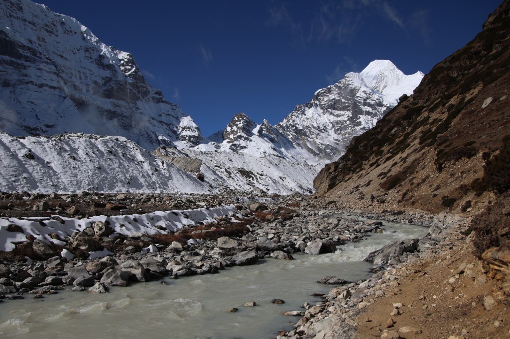
The Arun River
The other river is Barun, Arun’s main tributary. It originates from the Barun glacier at the base of Mt Makalu, the fifth highest mountain of the world. Both of these belong to the Koshi or Sapta-Koshi river system. This system drains the Eastern part of Nepal before reaching the plains of India. The other rivers in this system include Sun Koshi (or Indravati). Dudh-Koshi is the famous river flowing through the Solu-Khumbu valleys. The Tamor is in the Kanchenjunga area. The river Barun freezes entirely in winter. The upper section of its valley is one of the richest in Flora and Fauna. Yet, it is one of the least accessed regions of Nepal by tourists. It is so close to the famed Everest (aka Solu-Khumbu) region, yet so unknown among the travelers. It is right under the light of its more famous counterpart in the West. It is one of the richest habitats for birds in Nepal. Also the home of the illusive Red Panda. The valley shelters the Snow Leopard as well. The extreme lucky can occasionally get glimpses of these. The landscape varies from the tropical to the alpine. It ultimately reaches the base of its guardian, Mt Makalu, which oversees the valley.
The Barun valley lies entirely within the Makalu Barun National Park, which was established in 1992, as an extension to the Sagarmatha National Park (that covers the southern slopes & valleys of Mt Everest). In the early and mid 1980s, some members of The Mountain Institute were intrigued by the enigma of Yeti. They conducted surveys into the sections of the Barun valley. Their aim was to find an explanation of this mystic (rather mythical) phenomenon. In their attempts of doing so, they ended up revealing extraordinary biological richness of the area. That led to the need to protect one of the last remaining pristine forests and the alpine meadows (called kharkas in the Himalayan regions). The Makalu-Barun Conservation Area Project began as a result. Over time, this led to the creation of the Makalu Barun National Park. The region is inhabited by people of the Limbu, Sherpa and Yakkha ethnic groups. It is also home to the Gurung, Tamang, and Magar communities. Additionally, Newar, Brahmin, and Chhetri people mainly engage in subsistence farming.
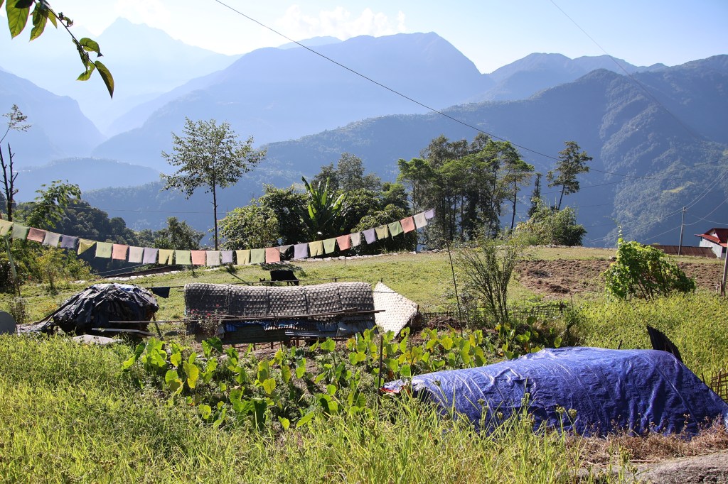
The lush green fields that line the slopes of mountains are obvious. This is clear as one makes way through the villages in the lower reaches of the region. The greenery appears to be much more than the neighboring villages of Solu-Khumbu and it’s very soothing to the eyes.

Let’s now turn our attention to the mountain which lends its name to this national park, Mt Makalu. At an altitude of 8485 m, it is the fifth highest mountain in the world. It is part of a section of The Himalayas known as the Mahalangur Himal. This section also includes Mt Everest, Lhotse and Cho Oyu. Many other peaks in this area are at or above 7000 m. It lies 19 km south-east of Mt Everest on the Tibet-Nepal border.

Despite lying so close to Mt Everest, Makalu receives much less attention from the climbers or trekkers. Sights of long queues extending up to the summit of Mt Everest are common nowadays. Climbs to Makalu are rare. The first climb was attempted by an American team led by Riley Keeganin 1954. It was called the California Himalayan expedition. It was attempted via South-East ridge, but was forced to retreat from 7100 m when they encountered with storms. Another team from New Zealand including Sir Edmund Hillary also attempted it during the same season (i.e. the spring of 1954), but were deterred by illness and injuries. Finally, on 15th May, 1955, Lionel Terray and Jean Couzy reached the summit. They were part of a French expedition team led by Jean Franco. Like Mt Annapurna, it was a French team, who tasted the first success on Makalu. The next two days saw three and four members of the expedition team summit the peak respectively. It was a major achievement at that time. Most of the expedition team members ended up summiting. This was unusual in those days. Typically, at most one or two members would summit. The rest of the team provided logistical and infrastructural support. This was done via the North face and the North-East ridge. In 2009, an Italian named Simone Moro accomplished the first winter ascent. He was joined by a Kazakh mountaineer named Denis Urubko. Before that, in 2006, the French mountaineer Jean-Christophe Lafaille disappeared. He was on the slopes of Makalu attempting a winter ascent. In 2022, Adrian Ballinger made the first ski descent. He skied from 15 m below the summit to the foot of the glacier.
We had our sights trained on this region from a very early phase. Still, we couldn’t venture out because of its remoteness. We scoured the internet for itineraries. We found many, but none were less than three weeks. This included a flight from Kathmandu to Tumlingtar. In the past, just reaching the starting point of the trek required at least 2-3 days. This was even after the flight from Tumlingtar. The duration proved to be a deterrent. It kept us at bay. We turned our attention to other areas of Nepal. After ticking off Everest, Annapurna, and Manaslu areas over the last nine years, we returned our focus to Makalu. By this time the road reach had extended further. This extension allowed us to fit the schedule to a window of two weeks. Now, reaching Seduwa, the starting point, is possible in a single day. This is achieved with a 30 minutes flight from Kathmandu to Tumlingtar, followed by a 7 hour drive.
Conversations started with our friends and Raju Gurung, our guide from Everest base camp and Annapurna base camp treks. Raju became a close friend of ours from these two treks. We wanted him to join us as a guide on this venture. After exchanging ideas, we fixed the itinerary. We made advance payments to Raju. These payments were for making arrangements for porters. They also covered advance lodge bookings and, most importantly, the flight bookings for Kathmandu to Tumlingtar and back. As per plan, we were to reach Kathmandu on 18th October, Tumlingtar on the 19th and arrive at Seduwa the same day. Successive nights would see us stay at Tashigaon, Khongma, Dobato, Yangle Kharka, Merek to finally reach at Makalu base camp. On our way down, we were to stay at Yangle Kharka, Khongma and Tashigaon. The last day would need us to trek to Seduwa, followed by a drive down to Tumlingtar. The itinerary looked good overall. Only one day raised doubts in my mind. It was the day we were supposed to get down from Yangle Kharka to Khongma. On the way up, the trek from Khongma to Dobato was 14 km long. It required crossing four different mountain passes, including the famous Shipton La (4170 m). This involved gaining elevation only to lose it. The final gain of height to Dobato was just about 100 m. After Dobato, it is about 12 km to Yangle Kharka. So, it involves descending a total of 26 km from Yangle Kharka to Khongma. This descent was supposed to happen in a single day. The stretch from Yangle to Dobato is mainly descent. Thus, it should take less time than ascent. The rest of the section was similar while going up. It would involve crossing the same set of passes. All these factors combined, gave me a feeling of a challenge. I felt it was going to be difficult with tired legs during our descent. It seemed almost impossible. I asked Raju the same question. He seemed okay with it. It seems most of the standard itineraries suggest that. I agreed to it at that time with crossed fingers. It’s another story that much of this itinerary went for a toss due to a multitude of reasons. Another cause of concern was the stay at Dobato. It had a single tea house. All texts on the internet suggested booking it in advance. This would avoid hassles after a long crossover across four mountain passes from Khongma. I often reminded Raju to make sure booking at that place. He assured us that everything was sorted. He had already informed local porters from that area to arrange for advance bookings. Apparently, there wasn’t any cause to worry (well, apparently).
Further inquiries revealed that this route could pose challenges unlike other areas of Nepal. Charging electronic devices or camera batteries may prove difficult. Access to telephone or Wi-Fi networks could also be problematic. This meant we had to equip ourselves with power banks and extra batteries. We also needed to set expectations with our homes. For a large section of the route, keeping them informed about our whereabouts could be a challenge. They should expect us to be off network for a sizable section of the travel. To be honest, this shouldn’t be surprising in a trek. However, in other established trails of Nepal like the Everest or Annapurna regions, the infrastructure support is improved. Because of this, our expectations for connectivity went higher. This was a trail which brought us down to earth. Still, when we went there, it didn’t turn out that bad in terms of connectivity. Though it was not as sophisticated when compared to the more famed trails of Nepal, it fared quite well.

Our last few treks in Nepal has been in the Annapurna region, the most recent was to the Khopra ridge. All of these travels involved entry and exit via Sonauli border (reachable from the nearest Indian railway station, Gorakhpur). This time, after a long period, we entered and exited Nepal via flights. The flights were to and from Kathmandu, the Nepalese capital. The team boiled down to three – me, Dhananjoy and Kunal. Dhananjoy would start on 17th evening via a train from Lucknow to Delhi. Rest of us were to join him at the Indira Gandhi International Airport for a flight to Kathmandu. Our return was going to be similar, except for Dhananjoy to take an onward flight from Delhi to Lucknow. A visit to Kathmandu would allow us to renew our ties to that city. We would probably visit the Pasupatinath shrine again. I always find this refreshing before starting over a trek.

One thought on “The Barun valley”