

27th April, 2025
It was unsually warm at Pokhara during the previous night. The hotel room didn’t have a fan, so we had to turn on the air conditioner to escape the heat and humidity. It gave me a sense of guilt (bordering to criminality) to turn on an air conditioner at a hill station like Pokhara. I’ve never faced it before. To limit the sense of guilt, I turned the air conditioner off after a couple of hours and opened the windows. Morning rituals took some time and after a fresh bath (the last occasion to do so before the trek ends), we headed downstairs for breakfast. We’d already transferred our luggage into the duffel bag. Yugal and Ramesh appeared at the doorstep while we were still at the breakfast table. After some delay, we boarded a Scorpio to embark on our journey towards the village of Ghandruk which was about 58 kms away. It was cloudy and none of the members of the Annapurna family were visible, which was a shame. It didn’t bode well for the rest of the day.
The vehicle made its way through reasonably corwded but disciplined roads of the Pokhara town and after approximately half an hour, it hit the highway. We were told that this highway led all the way to upper Mustang via the towns of Tatopani, Beni, Marpha, Jomsom, Muktinath & others. My mind sprinted through these towns along the highway and I recalled the reverse journey on this highway in the year 2022 on our way back from the Annapurna Circuit trail. This journey in itself is an experience. The lower reaches of it goes through lush green areas with the hills covered with dense forests. Gradually, these make way for dry and barren landsacpes of Mustang with mountain peaks keeping company all through. I still remembered the marvellous sight of the Jomsom airstrip with Mt Nilgiri rising beyond it’s limits. Marpha was famous for it’s apples and related products. Kagbeni, which is further ahead towards Muktinath, is a quiet abode where people prefer to spend a day or two for the natural beauty of the valley to sink in. The entire route travels along the famous Kali Gandaki river, which forms the world’s deepest gorge (reaching up to a depth of 1 km) up above in the upper Mustang region.
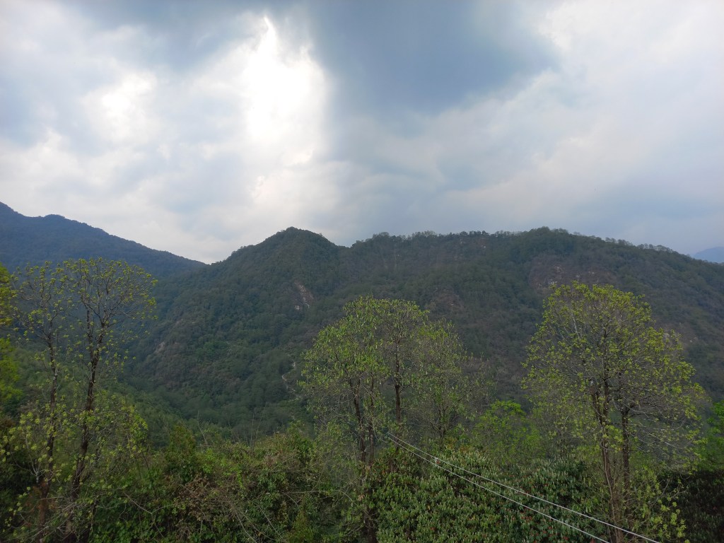
While I was engaged deep in these thoughts, our jeep took an exit from the highway to head down towards Nayapul where we saw a signboard indicating directions towards the places like Ghandruk, Ghodepani, Chomrong, Jhinudanda and others which dotted the different routes traversing through what is called the Annapurna sanctuary area (which covers the southern slopes & valleys of the Annapurna range). The sanctuary area is a subset of a much larger Annapurna Conservation Area Project (or ACAP, as the acronym goes) which also covers the Annapurna circuit trail and possibly, parts of lower and upper Mustang regions. After the turn, the road sloped down towards an old metallic bridge which led to some houses, shops & some govt offices. It was a busy place with a lot of people bustling around. This was where our ACAP permits got checked for the first time. The place is called Birethanti. I recognized it. It forms a gateway to the Annapurna sanctuary area and all routes emanate from here. We visited it for the first time during our visit to the Annapurna base camp. We had to halt to allow our permits to be examined and allow the govt authorities to register our entry into the area. Such entries are supposed to be matched during the exit to ensure whoever has entered, has also exited the area safely and no one gets lost in the trails. A similar exercise also happens at different checkpoints of other trekking routes of Nepal. We tasted the delicacy of local samosas. They tasted very different, probably due to the fresh vegetables (sourced from the local aggricultural fields) used in the curry that was stuffed inside. After the brief halt, the vehicle resumed it’s journey through the villages and forests of the sanctuary area. The road was still paved, but turned into a bumpy stretch after sometime as the jeep started to navigate through the curved hill sides. After sometime, we reached a junction from where one route moved further up towards Ghodepani through the villages of Ulleri and Banthanti, while we took the right diversion to climb up towards Ghandruk. The skies turned darker and after significant struggle to maintain its center of gravity, the jeep finally halted at a place, beyond which, walking trails awaited us. We disembarked and started our long awaited trek through the woods of the Annapurna region of Nepal. There was a very light breeze that caressed our faces, while we started the hike. We could see the Rhododendron trees, but they were devoid of flowers. What would have been a full bloom, had we reached here even about a fortnight earlier, was now absent. But there was no reason to complain as thick forests provided a canopy over the trail, which not only provided protection from sun (though it was absent for the day), but a cool breeze and more importantly, the much needed Oxygen which prevents one from tiring while walking on these trails. After about an hour of hiking, we reached the tea house where we were supposed to have our lunch. It was a resonably large place with wonderfully crafted and maintained gardens with lots of flowers.

The flowers shone even brighter amidst the looming darkness of the skies, which sent down sounds of distant thunders. As our lunch started getting prepared, we spent sometime to capture some snaps of the blooming flowers.


We enjoyed our first “dal-bhat” meal in Nepal after about a year. With hunger accentuated after hiking up from the starting point, the meal tasted even more delicious which was served with hot rice, lentils, vegetables, pickles and other delicacies of rural Nepal. After lunch, as I moved out to the open terrace, I felt a few drops of water on my body. Looking up at the sky, I saw the dark clouds hovering above. We still had at least two and a half hours of hike left for the day and chances were there that we may need to walk in the rain. We put on our raincoats and resumed our hike.
I could now see a few Rhododendron trees with a few flowers which were remnants of the full bloom that might have perished about a week ago. Colors of these flowers vary according to the altitude. The trees we saw now, had red flowers, but other colors make their appearances at the higher altitudes. The height of these trees also keep decreasing with altitude. The trees dotting the higher ridges are called “Dwarf Rhododendrons”. Rain droplets increased in their size and frequency as we moved up and after a point, we reached a place called Bhainsi Kharka, a conglomerate of lodges. That’s when rain came down hard and we had no option but to take shelter. I thought this was good in a way as it might clear up the clouds which could pave the way for a clear evening or even clearer weather for the coming days (or so we thought). I came up earlier while the porter, guide and Ranjan da were still behind. After a while, they emerged from the woods down below and made their way up to the dining hall of the tea house, which gave some warmth. After a a heavy downpour that lasted almost half an hour, the rain eased, but clouds still held their sway in the mountains. We took advantage of this let up and resumed our hike. After leaving the premises of Bhainsi Kharka, the trail moved up amidst a narrow alley. It was thickly forested and we had no trouble whatsoever while moving up. We kept our raincoats on, though they weighed heavily on us, causing a lot of sweat, but there was no choice as there were enough clouds to resume a downpour at anytime. While we were waiting at the dining room for the rain to subside, we saw a few lightning strikes with resounding thunder at distant places. Little did we know then, that these strikes would result in grief for someone.
When we finally reached Tadapani, it was still cloudy but the rain turned into a drizzle. The compound of the tea house was spacious with a dining hall taking the centerstage. A rear door at the end of the dining hall led to a corridor which had rooms on both sides. We settled into one of these, changed our clothing and headed for the dining space, which everyone vies to reach after a day of hike. It’s a place for socialization, gossip, reflecting on the day’s proceedings and making plans for the next day, while sipping away at hot tea. All through our way up, we kept hearing about marvellous mountain views which would have been at our disposal, had weather been kind to us, but such statements sounded more like fairy tales, given the current state of affairs at nature’s department. As we spent our time at the dining space, we saw the veil of darkness getting removed and gradually, light became brighter. The chorus of the trekkers outside gathered some energy, which prompted me to look out through the glass panes and wow, there it was, Mt Annapurna South and Mt Fishtail (Machhapuchare, as they call it in Nepal) made their appearance, still shielded somewhat by the clouds, bt their outlines were visible. The sheer size of these mountains gave an indication of the altitude of the place!
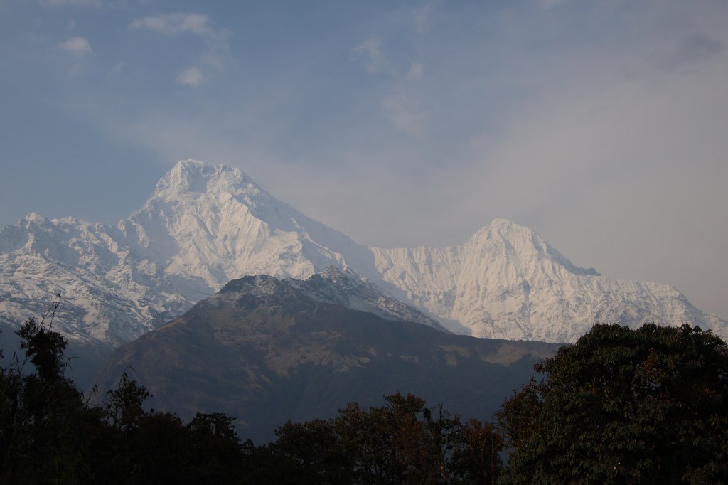
The sky cleared up further and immediately it lifted the spirits of the people around. Most of them ventured out of the dining place to train the lenses of the mobiles and cameras to the awe-inspiring display of the mountains. We were no exception and our shutters kept rolling in the fading afternoon sun, which started playing its color tricks on the snowy slopes of the Annapurna Himalayas. The emerging sunlight through the still powerful shields of clouds made the birds chirpy too and their sounds were all around us. We got so excited, that we made video calls to our homes to show this view to our family members back there. While I was at that, Ranjanda quickly reminded that this luck might not run long as clouds were still hovering and making advances towards the mountain tops. That prompted me to abandon the call and resume photography to snap up as many as possible till the luck lasts.
From the left to right, Annapurna South, Hiunchuli, many others in between (the guide told us their names, but I don’t recall) and finally the vista ended at the top of Mt Fishtail.

We couldn’t shift our attention from the mountains as the scenes kept changing continuously in the stage act played out by nature. On some ocassion, a mountain top was brightly visible, only to be shielded by emerging clouds, while others made their appearances and this kept on changing amidst the hide and seek between the sun and the clouds.

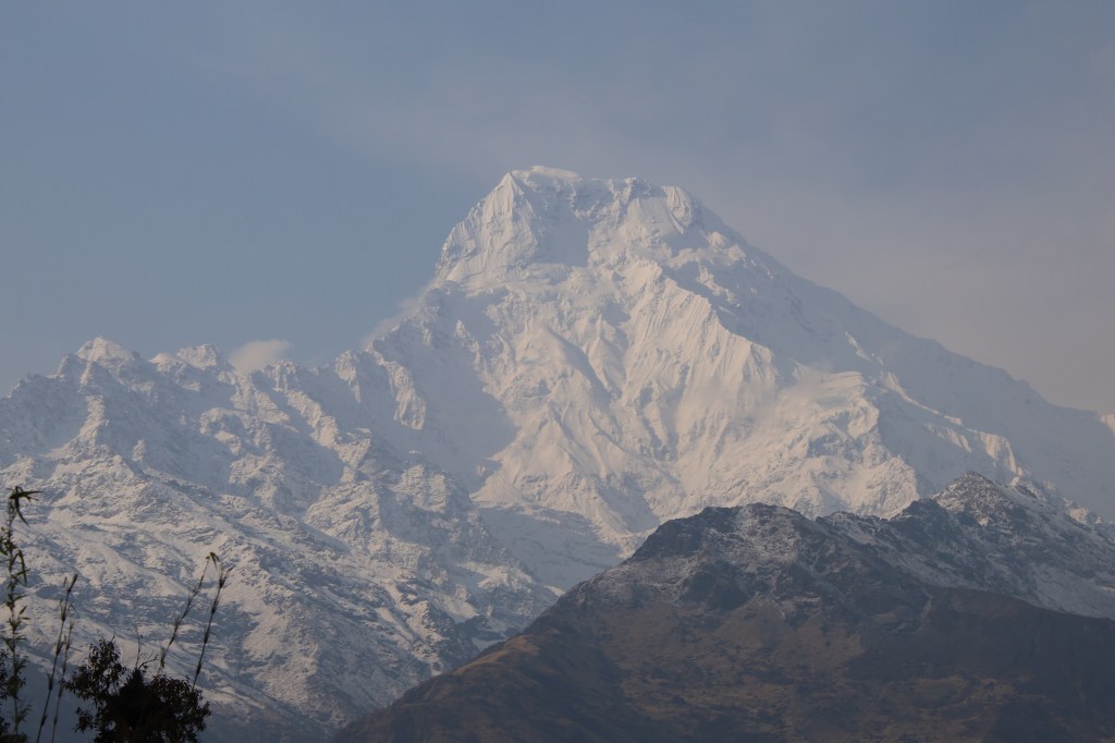
The most striking view was that of Mt Machhapuchare, which keeps inspiring awe, despite looking at it on multiple occassions from different places. We’ve seen it from different angles from Pokhara, the entire Annapurna base camp route, where it’s angles kept changing at every place, Mardi Himal trail and now on this trail.


Time flied by as we kept our lenses trained on the Annapurna Himalayas and they didn’t disappoint us, but after sometime, clouds gained their strength and made steady advances and eventually shielded them altogether. That prompted us to recline to the dining space. We had our dinner at 7 PM with sandwiches and soup and then moved to our room. The next day would take us to Dobato. We were sleeping at 2630 m.

2 thoughts on “The solitude of Khopra ridge – Tadapani”