
My stay in Delhi region meant proximity to the Western Himalayas. Hence, most of my Himalayan escapades has been to the regions of Garhwal, Kumaon and the state of Himachal Pradesh. My counterparts in Kolkata did the other way round as for them, visiting the mountains of North Bengal and Sikkim were easier. As a result, the likes of Kedarnath, Neelkanth, Chaukhamba, Trishul, Nanda Devi, Panchachuli and other Western Himalayan peaks were more familiar to me. Over the years, I’ve watched them with awe but one peak has stayed out of my views, Mt Kanchenjunga (or Mt KangchenDzonga, as some call it). It is the third highest peak in the world after Mt Everest and Mt K2 (Mt Godwin Austin). In my childhood and during my college days, I’ve had a brief view of it, but it was from a long distance from the hill station of Darjeeling. The state of Sikkim, in a way, lies at the footsteps of this great mountain.
Sikkim has been an independent kingdom since long, nestled between the neighboring kingdoms of Nepal and Bhutan in its western and eastern frontiers and India lying at its South and Tibet on its northern frontiers. It has been subject to invasions from these kingdoms. While they came to conquer or overrun its territories, they also left their influence in its culture and religion. The British also looked at it as a transit route to build trading relations with Tibet. An offshoot of the ancient silk route (a long trading route that originated in China, ran through the upper regions of the Himalayas into the markets of Central Asia) also passed through Eastern Sikkim. Over the years, the British had a sweet and sour relationship with the Chogyals (the kings) of Sikkim. They protected the kingdom by entering into treaties and defending them from the Gorkha invasions from Nepal, but to the other extreme, they ended up arresting the Chogyal and his wife when they came to Kolkata for negotiation. Later on, the relations improved somewhat and during the reign of Sidkeong Tulku, Sikkim obtained sovereignty from the British Monarch King George. Guarantees of Sikkim’s independence were later transferred to the Indian government in 1947 with India’s independence from the British rule. India controlled its defense affairs. During the Sino-Indian conflict of 1962, conflicts occurred at the Nathula pass (one of the passages to Tibet) and after the war, the route was closed. Later on, in 1975, Sikkim merged with the Indian union after a referendum.
First time we planned to visit Sikkim in 2008 but it was aborted at the last moment due to some emergency. After that, we visited many places in the Himalayas but Sikkim evaded us until the winters of 2015. As a part of our 2 week vacation towards the year-end, we planned to visit Sikkim for a week, followed by another week at my home town Kolkata. Two families (mine and my brother in law’s) embarked for Sikkim. They started a day earlier and stayed at Darjeeling for a couple of nights. We started a day later from Delhi by morning flight. Winter was starting to take its grip on Delhi. As we left our home for the airport, the air was chilling. Fortunately, there wasn’t any fog and that meant, our flight was on time. As soon as we reached heights, the Himalayas appeared on the northern horizon on a clear sky. We could easily identify the peaks of the Garhwal and Kumaon regions. they gradually gave way to the Nepal Himalayas. Somewhere, amidst these high peaks, Mt Everest must have made its appearance but I couldn’t identify it. Finally, Mt Kanchenjunga made its appearance with its siblings. The plane started its descent right after that and we touched Bagdogra airport at about 12 PM.
Bagdogra is a small airport. We went towards a counter where passengers were being allotted pre-paid cabs for different destinations into the Himalayan towns. We had to go towards Teesta Bazar and onward to a place called Bara Mangwa, a quiet place nestled in the hills around Kalimpong. However, we weren’t lucky and ultimately, we had to take cab for Siliguri and from there, we boarded another and by the time we were on our way towards Bara Mangwa, the sun was already bidding goodbye. After Teesta bazar, we turned left to move upwards. By that time, it was pitch dark and the cab was climbing the narrow roads with just its headlights on. We reached the lodge at around 7 PM. After dinner, we quickly resigned to our blankets and immediately sleep took control of us.
The next morning, we woke up to bright sunshine with clear skies.
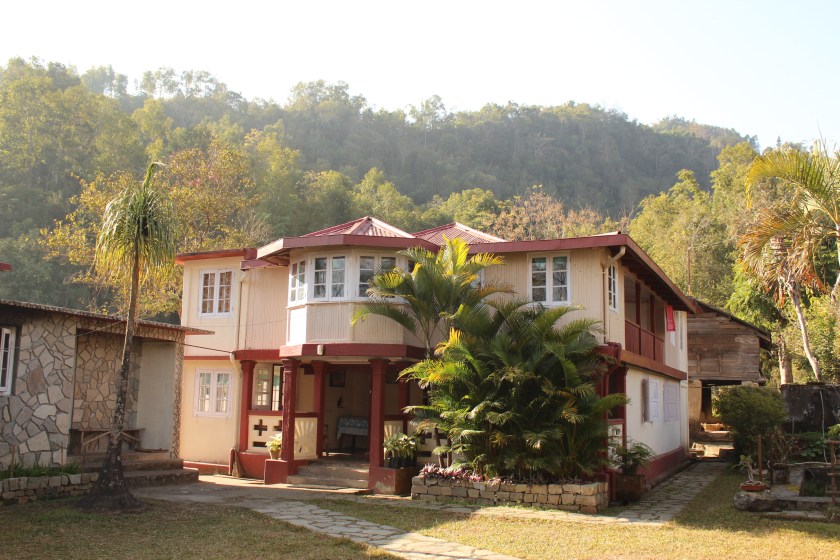
The home stay at Bara Mangwa was cosy, but we didn’t have enough time to enjoy, given the late hours we reached yesterday. Today, we had to leave early for Jorthang, an important junction in Sikkim. My brother-in-law’s family would meet us there and together, we were to start for Okhrey, a quiet town in West Sikkim. That was to be our destination for the day. After breakfast, we took a stroll nearby as we waited for our vehicle to arrive.

I hoped to visit an orange orchard, but I was told that the fruits were already plucked from the trees for the season. The chill of the morning breeze reminded us of our proximity to the Himalayas. Finally, we started off for Okhrey. On our way down, we visited an orange orchard, where, luckily, some of the trees still bore the fruits.

The plush green trees were dotted with oranges all around us. It was the first time in my life, I was seeing oranges in the trees. Like apple in the Western Himalayas, orange is a distinctive fruit in its Eastern flanks. The whole region consisting of Darjeeling, Kalimpong, Sikkim and the neighboring kingdom of Bhutan is famous for oranges and its derivative products. We then moved along till we reached Teesta Bazaar. From there, we had to turn left, but we went towards right to reach the confluence of the rivers Teesta and Rangeet, the two main rivers of Sikkim.

Teesta originates from the glaciers of Tibet in the regions north of Sikkim, then it flows down towards Darjeeling. Rangeet has its origin in West Sikkim and flows till it merges with Teesta near Teesta Bazaar, which then flows down the slopes to reach the plains of West Bengal before entering Bangladesh. It was a picturesque place with crystal clear waters of both the rivers flowing through the gorges of the mountains which are covered with dense green forests on their slopes. After spending sometime at the confluence, we continued our journey to Melli, which is a town on the border between the states of West Bengal and Sikkim. It is one of the towns that exist in both the states. The Jawaharlal Nehru bridge connects the two parts of it that lie along the two banks of Teesta. After crossing the bridge, we formally entered the state of Sikkim and as soon as we entered, we were greeted with horrendous roads. This was a surprise to me as roads in Sikkim are normally good (except its Northern part which was ravaged by a strong earthquake a couple of years ago and was still recovering from it). Apparently, the road was being widened by blasting the rocks in the adjoining slopes. These are causes of environmental concern as the Himalayas in general, are a fragile ecosystem. Especially, in these Eastern parts of it, rainfall is abundant and every monsoon wrecks havoc in the hills. Blasting in these areas will make the rocks even more unstable. We finally reached the town of Jorthang at around 1 PM and met with my brother-in-law’s family.
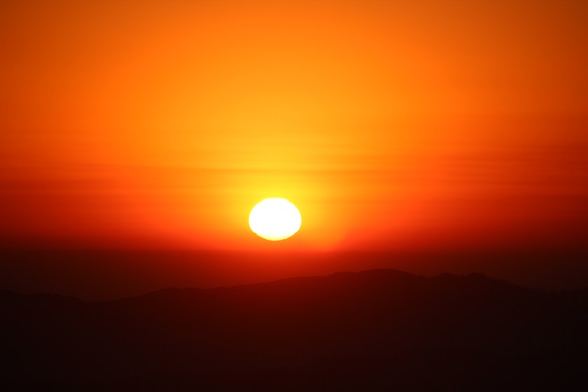
Jorthang is an important junction in this region which roads leading to different parts of Sikkim from here. I found it to be a bustling town. We were at the bus stand. The market nearby was flooded with oranges. We didn’t wait long and boarded a jeep for Okhrey. After Jorthang, as the jeep climbed the serpentine mountain roads, the wind chill increased. We reached our stay at Okhrey by the evening. The sun was still out. This was our base, from where we would be ascending to Varsey the next day. We were nearing the reaches of Mt Kanchenjunga. It was just another night and we’d at her doorsteps. Our plan was to stay at Varsey for two nights, but the owner of the lodge at Okhrey advised us not to stay there for more than a night as the facilities weren’t very good. But, who cares, we don’t luxury in the mountains as long as basic amenities like warm water and blankets are provided. But later on we realized that his words were correct to their letters. As darkness wore on, the mountain slopes on the left lit up with innumerable lights and we were told, that these were the lights of Darjeeling. When I woke up the next day, darkness was giving its way to soft daylight, which was spreading its arms gradually, but the sun was yet to rise. The sky was illuminated with soft daylight beyond the dark outlines of hills in front. Gradually, the soft blue started to acquire a tinge of red as if someone sprayed a patch of vermilion and sun started peeping out.
The shutters kept clicking on as the sun made its appearance in the sky. After sometime, we were ready after our morning duties to head towards Hilley, a town that is a few kilometers ahead of Okhrey. It was the place from where our short trek to Varsey was to begin.

One thought on “In the land of the Chogyals – part 1”