2nd November, 2019
The previous night went in discussing with other members about the luggage they were taking along. Speaking to different members led to different opinions about the number of items to be carried along. There was one problem to cope with. We won’t be coming back to the place where we start from. It was a circuit trekking. Unlike previous occasions, Kathmandu (neither Pokhara) won’t figure on our way of return. Pokhara won’t come at all, while Kathmandu was to figure on the route, only on our way to the Manaslu circuit. This did have a bearing on the luggage as we couldn’t have dropped some at a place to recollect on our way back. Given that, we had to go through varying altitudes, the clothes, particularly warm-wear would vary accordingly. The thermal inner-ware is useless in lower reaches. We also had to keep an eye on the weight of our luggage to be humane towards the porters who would carry them along for about eleven days. After many deliberations, each of us narrowed down to our respective luggage – leaving out what we thought to be unnecessary.
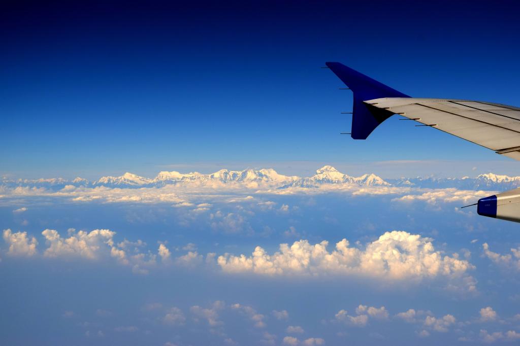
Just after breakfast, Ranjan da came down to my place with a cab and we both headed towards Terminal 3 of Indira Gandhi International Airport. Dhananjoy was in touch with us all throughout. He started from his quarters and boarded the Airport Express Metro to reach Terminal 3. The boarding queue was long but finally, we made it through the check ins to the departure gate. We were careful with our seat selection in order to get window seats to get glimpses of the Himalayas as soon as the aircraft took off. Before boarding the aircraft, we spoke to Niladri on phone. His train was running late by an hour. After that conversation, he went out of contact as he entered Nepal from the Raxaul border. We were deprived of the views during the initial part as clouds held a veil in front of The Himalayas. The ranges of Garhwal and Kumaon eluded us, but gradually the clouds cleared up and once we were passing the ranges of Central Nepal, we could clearly identify Dhaulagiri, the peaks of the Annapurna range and the “double-edged” summit of Manaslu, our destination.
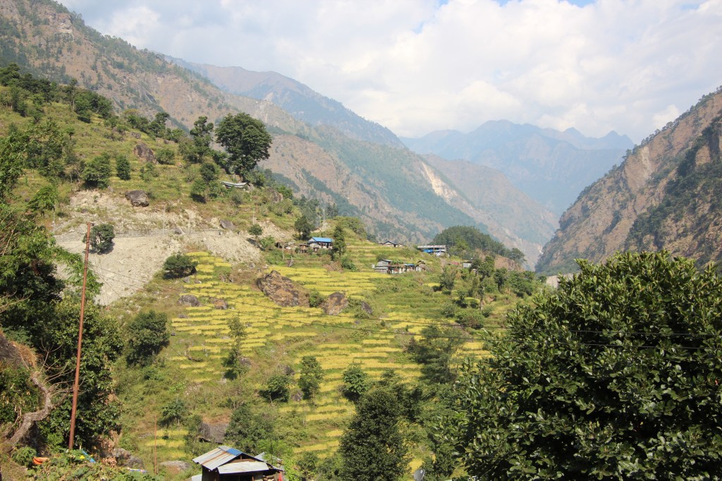
Unlike their Indian counterparts, the Nepal Himalayas didn’t disappoint. We had our eyes glued to the range as the aircraft went past them and started it’s descent towards the Kathmandu valley. We could see the valley surrounded by distant mountains, dotted with houses and fields. Temples and Monasteries stood out among them with their golden tops.
Before the trip, I started reading about the Annapurna expedition by the first climbing French team led by Maurice Herzog. Back then, the Kathmandu valley or for that matter, Nepal was a land of mystery offering limited access to the Western world. In order to reach Kathmandu, people had to travel by rail, then by road to a point. From there, a trek to cross a pass and again by road. But even this mode of transport couldn’t deter the royals from purchasing the modern cars or riding them on the streets of Kathmandu. Cars were carried by huge teams of porters (or coolies as they were called) who devised innovative ways of creating a platform of logs. The car used to be placed and fastened on top of that structure. This entire setup got carried by coolies through the roads, across and beyond the passes to Kathmandu.
We landed at the Tribhuvan international airport at about 1 PM, local time. It appeared all so familiar this time. The sky was clear with a very comfortable warmth of a November sunshine. A taxi took us through the Kathmandu streets towards Thamel, the tourism district of the city. We went past the Pashupatinath shrine on our way and reached the hotel Tibet Peace Inn. It is located just a few steps away from our place of stay for the Annapurna trip. After the formalities, we were served a welcome drink and then a local staff led us to our rooms. A few moments later, we ventured out to the streets of Thamel for lunch. Our plan was to have lunch and walk down to the Royal palace, about 3 kms from our place. After visiting it, the plan was to go to Basantapur Durbar Square, a must visit on the list of local sight seeings in Kathmandu. Hot, steaming momo served good for our lunch and after that, we started walking towards the Royal palace but as luck would have it, it was already closed for the day (we missed it by an hour).

Nevertheless, a few snaps in front of the palace, gave us some consolation and we started off towards Durbar Square. There was a glassy mall right opposite to the Royal palace. This, to me, came across as a sign of declining stature of the royals in Nepal, who, till a decade ago, commanded a lot of respect from the general public. In those days, it was impossible to have a commercial building obstruct the clear views of Royal palace from distance. But those heydays are a thing of past in contemporary Nepal. The statue of the former king Mahendra continues to adore the crossing in front of the royal palace. So do metallic sculptures of the kings Mahendra and Birendra, in the courtyard of the Pashupatinath temple.Unlike what some people said earlier, the Durbar Square turned out to be quite far from the Royal palace. We kept walking and asking the locals till we finally reached there. It was a slice of ancient Nepal amidst the modern streets of Kathmandu.
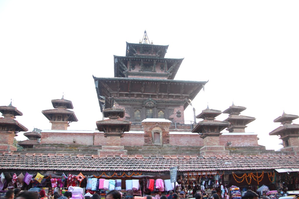
The area was dotted with ancient temples and structures all around. Tourists from all around the world thronged the place. Shopkeepers were busy luring them with their “best deals”. Tourists enjoyed the local street food and the numerous monkeys kept constant vigil with the hope of confiscating them.

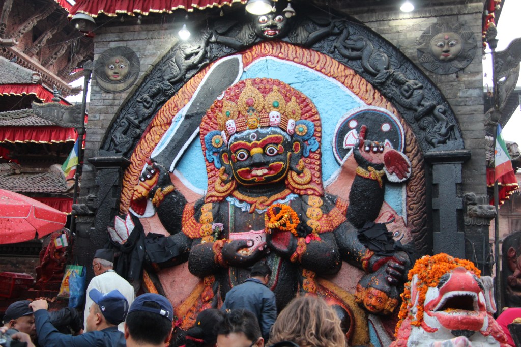
Another attraction of the Durbar Square was the idol of Kal Bhairav – a deity that gets worshiped by locals, in the hope of warding off the evils.
After the visit to the Durbar Square, we came back to the hotel to await the arrival of Niladri. We had to be present before his arrival as there was no way we could communicate with him on phone. Finally, when his figure entered through the door, it seemed to me, once again, a slice of Kolkata, my native place, with a freshness, arrived in my life after about six months (since my last visit during the summers)! We ordered tea as soon as he arrived and a tea conference ensued (first of the many that would follow throughout the trip). Niladri pulled out some snacks from his bag, in which he carried a load of items that included tea bags and a steel mug for each one of us. All of these were a part of a strategy to reduce cost (food costs go extremely high, especially at the higher altitudes). The hotel had WiFi, which allowed us to contact our homes to announce our safe arrival. I gave a call to Tej Bahadur Gurung of Nepal Alternative Treks to inquire about our permits. We also had to meet him in the evening to submit our passports and pay our advances for him to arrange for our permits. We met him in the evening at his hotel to hand over our documents. He would send his men to the permit office the next morning and it could take till noon to get them done. After that, he’d arrange for a vehicle to take us to Sotikhola, which is where our trek would start from. We arrived in Kathmandu on a Saturday, the weekly off day in Nepal. That’s the reason, the permits had to be done the following day. After meeting Tej, we had our dinner at a local restaurant in Thamel and returned to the hotel. Plans were drawn up for a visit to the Pashupatinath shrine in the early morning, the next day.
3rd November, 2019
We woke up next morning and after the morning bath and a small tea session, we headed for the Pashupatinath shrine as planned on the previous day. The taxi took us through the dark streets of Kathmandu to the shrine. We walked down the lanes, all familiar since our visit last year. The temple courtyard was bustling with devotees and monkeys alike. After a visit of the idol, we started a walk around the courtyard (a Parikrama). It was all the same as before. The temple, the morning tolls of it’s bells, the chants by the priests and also, the cremation ground at it’s backyard. We crossed over the Bagmati river to it’s other side to have a view of the temple complex from elevated banks on that side.

On our way back to the hotel, we boarded a bus which took a different route that wandered through the streets of Kathmandu and dropped us at a place, from where we had to take a walk towards Thamel. On our way, we had breakfast. Finally, at about 11.30 AM, Tej Gurung gave us a call that our permits were ready. We took our bags to the place where the vehicle awaited us. We met our guide and one of the porters. Bidding goodbye to Tej Gurung, we started off on our journey. Another porter, Naveen, joined us en-route. The vehicle headed out of the Kathmandu valley along the highway to Pokhara. From Benighat, it left the Pokhara highway towards the town Aarughat. The afternoon was bright and the sun showered its golden rays over the paddy fields we passed by. The road started meandering up the slopes till it reached a point where Asphalt gave way to mud and boulders. We knew earlier that the secion of the road from Aarughat to Sotikhola was totally made of boulders, but it turned out that the stretch started much earlier, even before Aarughat. Evening was bearing on and we had to reach Sotikhola before dark. The vehicle kept bumping up and down on our topsy turvy ride. The road moved along the banks of the river Budhi Gandaki which came down the slopes with it’s water frothing along the rapids formed by it’s uneven bed. When we finally reached Sotikhola, the last trace of daylight was leaving the lower reaches of the valley, while the upper slopes of the surrounding hills still bathed in sunshine, a common phenomenon in the mountains. Our guide found a tea house and we subsided into our rooms. A tea session followed soon. Let me describe these tea sessions as it merits some mention. It usually started with Niladri puling out some tea bags from his repertoire. All of us then followed by pulling out some snacks (biscuits, chocolates, dates etc.) from our respective bags. We ordered a jug of hot water from the tea house. Mugs came out and tea got prepared by dipping the bags. Dhananjoy preferred having his tea bag dipped for at least 5 minutes before consumption. Apparently, that yielded a much better flavor (a fact which served as a basis of immense leg-pulling throughout the trip). It was then followed by candid discussions, friendly banters, leg pulling and plans for the coming days. We responded to a call for dinner at 7 PM to come out in the lawn in the chilly evening. The sky was pitch dark, studded with some stars. The guide gave us a lecture about the morrow’s plan (a pattern that would follow throughout the route). It had a fixed agenda and was spoken in a unique accent (more about it later) which was difficult to decipher. As per the plan, our next destination was Machhakhola. Finally, the day arrived when we’d hit the trail, once again! We subsided under blankets for the night. We were sleeping at 700 m.