
In the previous evening, a Sherpa guide from Solu Khumbu tried to impress us with some playing card tricks. He couldn’t quite succeed fully to generate the awe in us as he would have expected. The reason is, some of our team members were well aware of the skills and in fact they returned him the favor by showing some to him. Nevertheless, we enjoyed the evening.
14th November, 2019
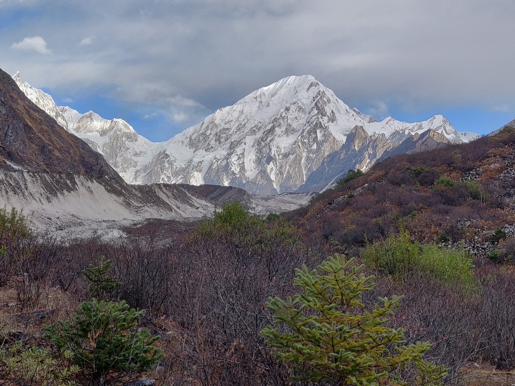
We woke up to a relatively clear sky. Though clouds still hung around, the mountain peaks were visible all around Bimthang. It is a picturesque valley and deserves a day or two in its own right. It can be a good place of rest or even hiking around if one had interest. While I went to wash my face, I could see the solar rays streaming out breaking through the hanging clouds from behind the towering mountain peaks.

I had my sleep last night and felt fresh. I stood for a moment to look around the mountain ranges surrounding Bimthang. One of the peaks was supposed to be Mt Manaslu, but I couldn’t recognize it since the famous double edged view that one gets to see from Samagaun isn’t available from Bimthang. The peaks on the Western horizon are from the Annapurna range.

It could have been a day of leisure for us, given that it was to be our last day of walking in the mountains, but we had a long way to go. Though downhill, Dharapani was quite a distance away from Bimthang. The breakfast did have some more variety, but I stuck to corn flakes with milk and apple. Our guide gave us an overview of the day’s walk. The trail follows the Dudhkhola river, traverses through the lush green pine forests and villages like Yak Kharka, Goa, Tilije and finally, culminates at Dharapani, where it meets the famous Annapurna Circuit trail that comes down from Manang. The route beyond Dharapani is said to be motorable, but as we found out later, its not a paved road. It has just been widened to allow vehicles to ply, but many trekkers prefer to walk in that section too. Though, plying vehicles with nothing but somewhat leveled rocks to roll upon has made it a nightmare for walking. With ever advancing road network on both sides (Sotikhola as well as Dharapani), the fate of Manaslu Circuit trek is at stake. Similar to what has transpired on Annapurna Circuit route (which now doesn’t offer more than three days of trekking), its a grim future that awaits the circuit. Very soon, many lodges and tea houses along the route can face extinction as it has happened to places on Annapura Circuit once vehicles started to ply till Manang.

We put on our gears and at the insistence of Dhananjoy, posed for a group snap and headed down the trail. The route meandered lazily out of the village of Bimthang into the wilderness of the banks of the roaring river Dukhkhola. The many twists and turns of it, the sandy banks sprinkled with boulders and pine trees, the not so distant mountain ranges formed post card frames at every round and corner. This added to the time as most of us rolled our shutters on as we moved through the valley.
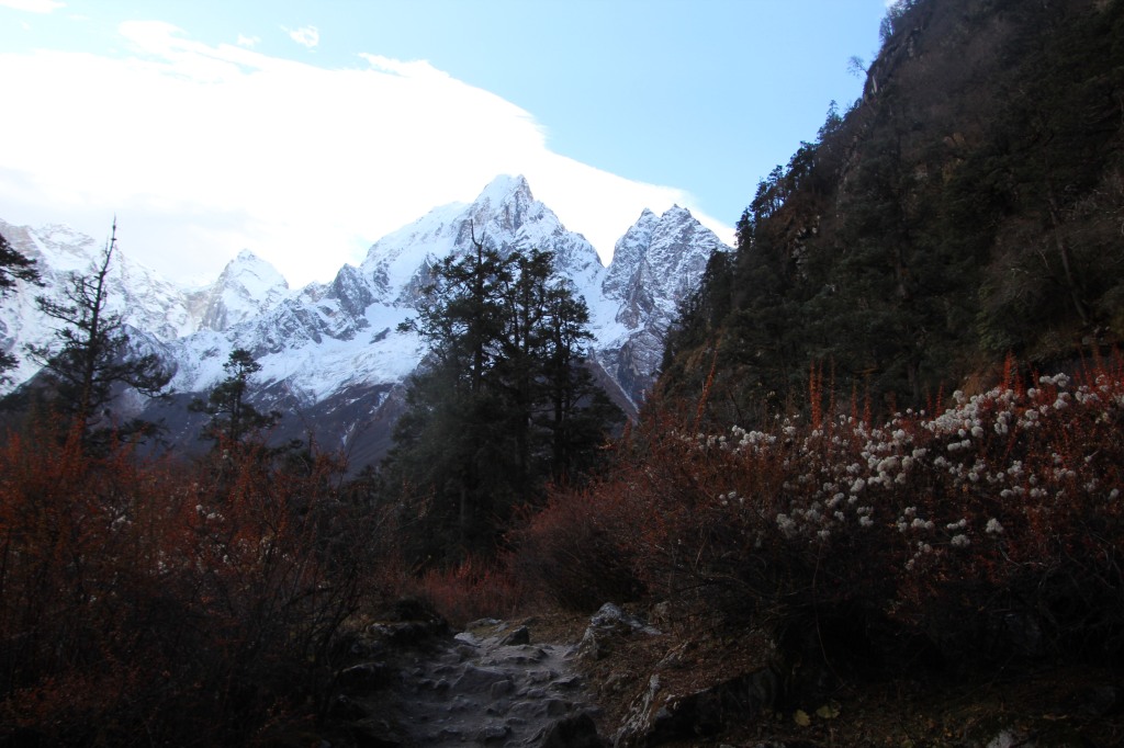
One seldom gets to hear about this section of the trek. Most of the blogs, descriptions and itineraries of Manaslu Circuit mainly focuses on places like Lho, Samagaun and Larkya La, but what we realized on our way down that the descent was equally charming. After a few bends, a board welcomed us to the Annapurna Conservation Area. We were now going through the district of Manang. The river flowed through the valley in twists and turns. Its banks were flanked by a layer of boulders on both sides, beyond which, there were bushes and shrubs of brown, yellow and at times, red. Wild flowers bloomed amidst them. The name Dukhkhola (not to be confused with DudhKosi, which comes down from the Everest region) was very appropriate, thanks to the rough bed on which the water flowed upon, creating multiple rapids and turbulent currents causing the water to acquire the color of white (resembling milk or “Dudh”, as they call in Nepalese). The term “Khola” means river.

A signboard displayed that the next place Yak Kharka (Chauli Kharka, as some call it) is about 1.15 hours ahead and so was Bimthang, but in the direction where we came down from. As always, small milestones do help to set targets in a long journey and for us, Yak Kharka was the immediate next. When we started from Bimthang, the vegetation was sparse as Bimthang falls in a rain shadow area and receives less rainfall. But as we moved downhill, trees started to increase. The trail now moved into increasingly dense vegetation which lent stability to the track. Appearance of vegetation meant the track was not just composed of gravels as was the case in higher altitudes, but had soil as well which were held by the roots of the surrounding trees.
A look at the sky revealed that clouds were making their way through. While they were yet to cover the snow peaks, but their colors revealed that rain might not be far away. We stepped up our gears in order to make it to Yak Kharka as quickly as possible. But the nature at our disposal made it difficult. We couldn’t help not stopping for photo shoots and our guide kept urging us. His idea was to get to Goa as soon as possible (yes, you heard it right, but its not the beach holiday destination of India, but a mountain village). Goa was to be our place for lunch. He had his reasons to think that way as the more close you get to Dharapani with sufficient time at hand, the better.

On our way through the forests, we often noticed, tree trunks lay down across the trail and we had to cross over or at times, under them, to make our way through. It gave an ominous sign. Not all of them appeared to have been brought down by storm or landslides but indicated a human hand behind their fellings. When we reached Yak Kharka, the structure of the newly built tea houses made us believe that they were the consumers of the felled trunks. The irony is that this area is supposed to be a “Conservation Area”.

We didn’t stop at Yak Kharka except for a few minutes to gulp down some water. After Yak Kharka, the guide made us aware of a land slide zone lying ahead. Now that we’ve crossed many of them, it didn’t cause me worry and I plodded ahead along the banks of the river amidst the forest. The path gradually moved downhill and as soon as it came out of the forest, we were on the banks of the roaring Dudhkhola and we could see the entire land slide zone ahead of us.

A huge swathe of land as if has been sliced away by the river exposing the inner lining of the rocks. In absence of a proper trail, a much narrower track mainly marked by foot steps of trekkers and mules formed a zig-zag way up the banks till it regained the original track way ahead. Before reaching this place, we kept coming across felled logs and trunks and we wondered whether these acts were the reason behind this landslide. Though such incidents are common in a young mountain range like the Himalayas, but they might as well have accelerated the process in this area at least, which is otherwise densely surrounded by forests which should have lent relative solidity to the ground.

We had to reach the banks of the river and then a steep ascent awaited us along its sides on a dusty, gravel-stridden track. It was difficult maintaining grip with ever sliding dust and pebbles threatening to unsettle every moment. I trained my eyes in front where I could see other members who already were beyond this stretch and were resting on the ground above. That did two things for me. One, it did take away my attention from the ground below and two, it gave me some motivation to reach that point as soon as possible. When I finally ascended and regained the original track, I looked behind and stood for sometime to look down below to have a glimpse of the track that I just traversed.

As we approached Goa, the number of settlements started to increase. We could see herds of mountain goats grazing amidst the forest. After a few bends we could see the settlements of Goa, our destination for lunch. A trekker who passed by me whispered “Wow, there’s food ahead! I might as well head down fast.” and almost ran down the slopes. In a moment, he was out of my sight.

After I reached the outskirts of Goa, I found Niladri waiting for us and the guides to know about the tea house where we were headed, but Dhananjoy was not in sight. He seems to have moved ahead. The guide reached after sometime from the rear and we followed him to the destined tea house. After washing our faces, we sat on a table for a much needed rest. The sun played hide and seek with the clouds as we awaited our staple lunch of the Nepalese “Daal bhat”.

When we were having our lunch, our guide took a shower at the tea house. That prompted some of us to think about it. But the cost involved in it, prevented us. It’s quite tempting since the last time we had a shower was back in Kathmandu and we yearned for it. Our guide told us that the trail beyond Goa is relatively level and wide enough as it’s been widened for vehicle travel, which should soon reach the place in the years to come. Our next milestone was Tilije, about two hours ahead of Goa. The trail moved on relatively less steeper grounds. Consistent with our guide’s statement, it did indeed widen up and we walked along pleasantly in the fading afternoon sun. I walked aside Niladri for some distance and we mused about our next trekking destination. Kanchenjunga appeared in both of our minds, but question was whether we should attempt its base camp via Nepal or go to Goecha La via Sikkim. The route via Nepal takes longer (almost three weeks). In that sense, Sikkim might be more preferable. But that was for future (at that time, future meant the next year, which, unfortunately, didn’t quite turn out that way).

Tilije was a relatively large village and there were quite a few houses. It was almost a town with many alleys and we went through them to reach the other bank of Dudhkhola. Our guide told us that most of the tea houses in this section of the trail (i.e. from Larkya Phedi to Tilije) are owned by members of this village. During the trekking season, they go up and man the tea houses and come down again as winter settles in. Beyond Tilije, we could see JCBs working their way out by tearing apart blocks of mountain walls to pave the road for vehicular traffic. As a result of that, the road was dusty. We yearned for the sight of Dharapani settlements and sped along. After about 1.5 hours of walk, we crossed over a bridge to the other side of the river and could see some settlements. We breathed a sigh of relief but knew little that the huts we saw, belonged to a different village named Thonche.

As we moved through the streets of Thonche, children from the local village gathered around us and we obliged them with toffees (as we had done throughout the trail). Beyond Thonche, we had to cross another river (the Marsyangdi khola) to reach Dharapani finally. The rooms allotted to us were quite spacious. We hung up the wet clothes and changed gears. At the evening tea session, people were all relaxed and were celebrating. We exchnged greetings with the German couple, our companion for this entire trek. Porters started singing as we captured their videos. We made calls to our respective homes to announce our arrival and the completion of the trek. After arranging a vehicle for the next day to take us to Besisahar, we moved to our respective rooms. We were sleeping at 1860 m.
15th November

We woke up to a relatively clear morning at Dharapani. Instead of spending time at breakfast, we thought of starting early. We could see the vehicles plying on a dusty road slightly above the ground where our tea house stood. A few steps got us to the jeep that awaited us. Before that, we had to show our permits to the Annapurna Conservation Area office where they made entries about our details in their journals and off we went towards Besisahar.

At Besisahar, we bid goodbye to our guides and porters who headed towards Kathmandu and we took another vehicle towards the plains. Along the route, Marsyangdi khola kept company and so did the distant mountain peaks of the Annapurna range. I could hear them calling “When do we meet again?”

These are some of the best pictures I have seen in the trek so far. What an amazing time it would have been. Sad to read about the fallen tree trunks inside the conservation zone. Also, the roads coming up is not a very good news for trekkers though it is probably good for the villages. “Goa” was interesting. I almost thought it’s our Goa. And, Goechela was on my list too this year. Perhaps the mountains are breathing with lesser footfalls or maybe they are missing us. 🙂
Thank you for taking us through this virtual experience. I have lived your journey through these.
LikeLiked by 1 person
Thanks a lot. There is also a short trail for Manaslu which goes from Dharapani till Larkya La & back, for people who have less number of days at their disposal.
LikeLiked by 1 person
Thank you Indranil for sharing your experiences on the Manaslu Circuit. I really enjoyed reading it and your writing style brings the track to life! I also enjoyed reading about the friendship in your group with the different characters. It kind of reminds me of my friends group who all have distinct characters and we make fun of each other a lot. I will be doing the Manaslu Circuit with the family in May this year and we will bring our 15 year old twin boys. They will be up for a unique experience! Thanks again!
LikeLike
That’s really encouraging. I wish you the very best for your upcoming Manaslu trek. It’s one of the treks which still retains the ethnic culture.
LikeLike